
Detection
A Forward Flank Notch (FFN) signature, also known as a "flying eagle" or "flying V" signature, is named after the shape of the reflectivity echo along the leading edge of certain thunderstorms. This signature is typically, but not exclusively, found in the midlevels.
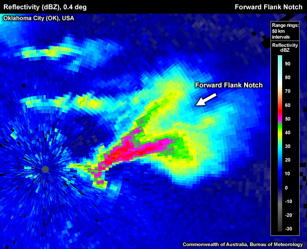
Pronounced FFN at low levels associated with a tornadic supercell just east of the Twin Lakes radar east of Oklahoma City on 3 May 1999.
The creation process for the FFN include a downshear dynamically created low in a situation where strong storm–relative flow interacts with a strong and persistent updraft, Bernoulli acceleration on the flanks of a storm with a strong updraft, or a wake eddy effect. The FFN should be distinguished from the "inflow notch" created by low–level, hydrometeor–sparse inflow into an updraft (see look–a–likes below). To determine if the signature you are seeing is a FFN use the following technique:
Reflectivity: PPI/Plan View
- Step up in elevation until you are viewing the middle elevations of the storm.
- Look for a V shape on the leading edge of the storms core. This is more often evident in the lighter reflectivities (>45dBZ), but is sometimes present in stronger reflectivities .
- Is there a V shape evident on the leading edge? If yes, a FFN is present.
Potential Difficulties in Detection
Deceptive colour transitions – FFNs can be hard to recognise, as the signature might be embedded in a part of the reflectivity colour palette where the colour changes very slowly with increasing reflectivity values.
FFN signature in the 25–40 dBZ range is only apparent in the light blue and yellow colours.
Examples of Forward Flank Notches
Pronounced FFN at low levels on the northeast flank of a tornadic supercell just east of the Twin Lakes radar east of Oklahoma City on 3 May 1999.
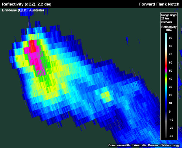
FFN signature on the storms southeast flank.
Note that the FFN signature on the southeast side of the storm is most pronounced in the lower reflectivity values.
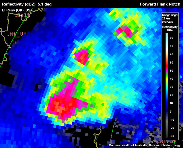
A pronounced FFN as part of a right–moving supercell near El Reno (Oklahoma, USA).

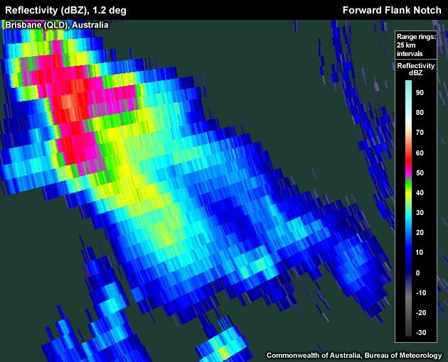
Not a "classic" FFN, located on the northeastern side of the storm.
Forward Flank Notch Look–a–likes
The most common FFN look-a-likes are:
- Inflow notch – this is the most common error made in diagnosing a FFN signature. The inflow notch is located in the low–levels of the storm on the inflow/updraft side.
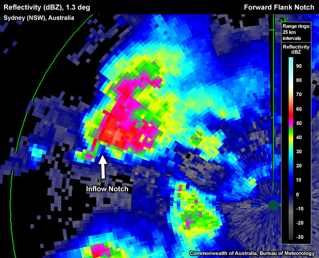
Inflow notch located in the low levels in the sparse radar target area of the updraft/inflow.
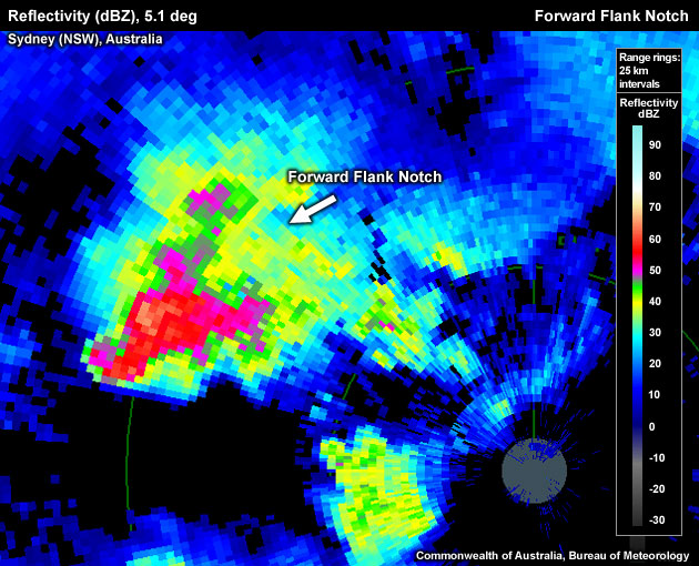
This is the correct identification of the forward flank notch for the storm analysed in the previous image. It is located in the mid–levels on the leading flank of the storm.
- Cores from multiple updrafts - Multicell storms can create a horizontal reflectivity distribution that may resemble the shape of a FFN.
- Three–body scatter spikes (TBSS) – this signature can create a reflectivity distribution that may appear to possess forward flank notches through false echoes.
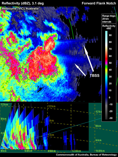
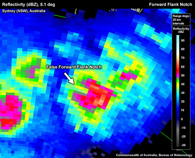
Three-body Scatter Spikes signatures from hail cores have produced a "false" forward flank notch.
- Wrong storm position - False FFN not downstream of the updraft.
"False" Forward Flank Notch, recognisable based on the location in relation to the thunderstorm.