Conceptual Model
The Very High Reflectivity signature is used as one of many signatures pointing towards a severe thunderstorm. The presence of a Very High Reflectivity echo indicates the thunderstorm possesses a strong updraft, as it is able to create very large radar targets aloft. For example, a rotating storm is more likely to possess a strong updraft, keeping the hailstones in the storm longer or making their liquid path longer. The presence of a layer of hail is likely, especially if the updraft extends past the freezing level, ideally into the -10°C to -30°C region, where abundant amounts of supercooled liquid is typically found. A strong updraft can suspend large hydrometeors (usually hail), preventing precipitation from falling back through the updraft.
Very High Reflectivities directly indicates the presence of large hail or large amounts of small hail/large raindrops. As the calculation for assigning reflectivity values is performed considering the integral of the number of drops by the size of their diameter in a certain volume, the values get to a point where they can no longer be representing large drops due to the physics of surface tension. In describing the S-band three-body scatter spike (TBSS), Lemon (1998) uses a highly reflective (>63 dBZ) echo core as representation of likely large, wet hail.
Large hail and/or heavy rainfall leading to flash flooding are both phenomena that can be produced by a strong updraft and are both used as criteria to determine a severe thunderstorm in Australia. To help determine the likelihood of one or the other, a good handle on the freezing level of the environment is required. If the very high reflectivities reside in a layer where the storm environmental temperature is below 0° C, it is highly likely that hail is being observed. On the other hand if the temperatures are above freezing, there is a possibility that higher reflectivities might also indicate a large amount of larger raindrops. Reflectivities greater than 70 dBz require consideration of giant hail (>5 cm). An issue to consider here, especially when you have a very deep warm and saturated layer below the freezing level, is that extreme melting could weaken the potential for large hail at the surface. Damaging winds should also be considered, especially if large hail is included.
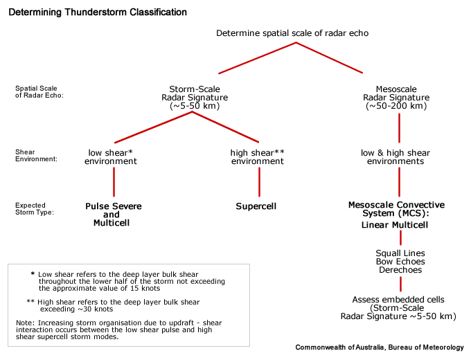
Determining Thunderstorm Classification
Very High Reflectivity signatures could be found in all three of the conceptual models we have included in this module. Very High Reflectivities can be found in pulse severe thunderstorms, although they dont tend to be as high or extend spatially as others. They are very copmmon in supercells and less common in mesoconvective systems which might be made up of a combination of severe or non-severe individual cells.
To help determine the classification of the thunderstorm you are observing, use the following flow chart to help diagnose which thunderstorm conceptual model you should consider more closely.

