«- back to print version table of contents
Very High Reflectivity
Detection
Very high reflectivity echoes are subjectively defined as echoes greater than 60 dBZ. It is around this subjective reflectivity threshold that the scattering hydrometeors are likely to contain large hailstones.
Core containing approximately 75 dBZ returns almost certainly indicates large hail. Optimum high reflectivity returns are around the freezing level where hailstones are at their maximum size and develop a coating of water that maximises their effectiveness as radar targets.
Consideration of the height of the high reflectivity is required, as a 60 dBZ echo above the freezing level is likely to be large hail. On the other hand, a 60 dBZ echo below the freezing level, could be either large hail or a large amount of precipitation. To determine if the signature you are seeing is very high reflectivity use the following technique:
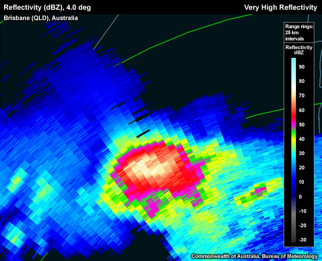
Reflectivity: PPI/Plan View
- Step up and down the elevation scans until you find the strongest core.
- Move the cursor over the pixels. Note: make sure you have zoomed in enough to clearly delineate between each individual pixel.
- Read off the dBZ value from the scale bar on the right hand side of the PPI window, or the cursor data window, or the info bar at the bottom of the PPI window (varies with radar display software).
- Record the highest dBZ value.
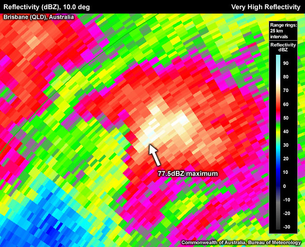
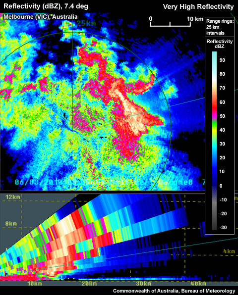
Manually scanning the reflectivity pixels shows the maximum reflectivity as 77.5dBZ.
Alternatively, overlay the WDSS or TITAN algorithm properties table. These values are approximate values,and not likely to contain the extreme values, as these algorithms remap the raw reflectivity data onto a different grid.
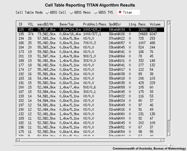
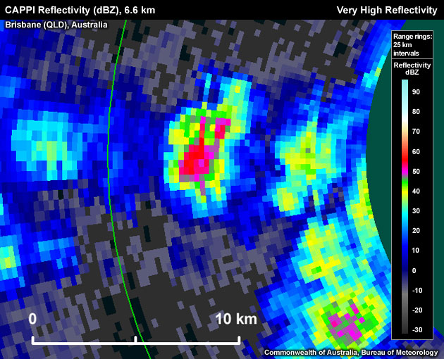
TITAN algorithm reporting the maximum reflectivity as 75 dBZ at 7.8 km
Note that even large hail might not show up as high reflectivities if it is very dry.
Potential Difficulties in Detection
- Attenuation – Especially on C–band radars, reflectivities in cores that are located downrange of another intense core are underestimated in intensity.
- Radar proximity – If a thunderstorm is too close to the radar, the beam may undershoot the signature
- "Noisy" data Occasional, usually isolated, "hot" reflectivity pixels not representing the true energy scattered by large hydrometeors (eg. ground clutter).
Examples of Very High Reflectivity
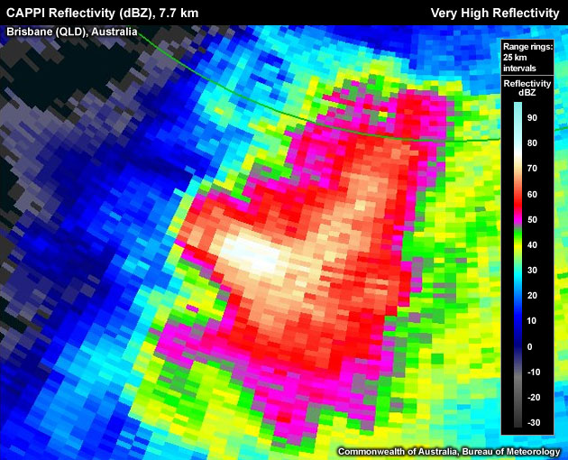
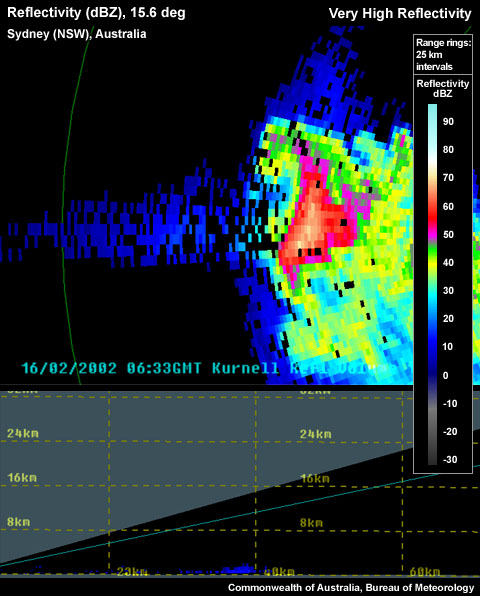
Core containing approximately 77 dBZ returns almost certainly indicate large hail.
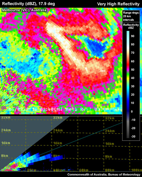
Core containing approximately 70 dBZ returns almost certainly indicate large hail. A Three-Body Scatter Spike (TBSS) is also evident downrange of the storm.
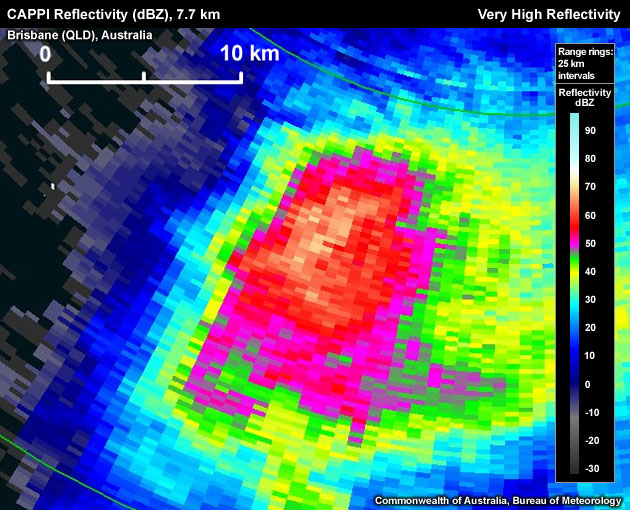
Core containing approximately 78.5 dBZ returns almost certainly indicate large hail.
Look–a–Likes
- "Noisy" reflectivity data can produce meteorologically incorrect reflectivity returns that can appear to resemble extreme values (eg. ground clutter).
- Ground clutter storm needs to be close to the radar.
Conceptual Model
The Very High Reflectivity signature is used as one of many signatures pointing towards a severe thunderstorm. The presence of a Very High Reflectivity echo indicates the thunderstorm possesses a strong updraft, as it is able to create very large radar targets aloft. For example, a rotating storm is more likely to possess a strong updraft, keeping the hailstones in the storm longer or making their liquid path longer. The presence of a layer of hail is likely, especially if the updraft extends past the freezing level, ideally into the -10°C to -30°C region, where abundant amounts of supercooled liquid is typically found. A strong updraft can suspend large hydrometeors (usually hail), preventing precipitation from falling back through the updraft.
Very High Reflectivities directly indicates the presence of large hail or large amounts of small hail/large raindrops. As the calculation for assigning reflectivity values is performed considering the integral of the number of drops by the size of their diameter in a certain volume, the values get to a point where they can no longer be representing large drops due to the physics of surface tension. In describing the S-band three-body scatter spike (TBSS), Lemon (1998) uses a highly reflective (>63 dBZ) echo core as representation of likely large, wet hail.
Large hail and/or heavy rainfall leading to flash flooding are both phenomena that can be produced by a strong updraft and are both used as criteria to determine a severe thunderstorm in Australia. To help determine the likelihood of one or the other, a good handle on the freezing level of the environment is required. If the very high reflectivities reside in a layer where the storm environmental temperature is below 0° C, it is highly likely that hail is being observed. On the other hand if the temperatures are above freezing, there is a possibility that higher reflectivities might also indicate a large amount of larger raindrops. Reflectivities greater than 70 dBz require consideration of giant hail (>5 cm). An issue to consider here, especially when you have a very deep warm and saturated layer below the freezing level, is that extreme melting could weaken the potential for large hail at the surface. Damaging winds should also be considered, especially if large hail is included.
Determining Thunderstorm Classification
Very High Reflectivity signatures could be found in all three of the conceptual models we have included in this module. Very High Reflectivities can be found in pulse severe thunderstorms, although they dont tend to be as high or extend spatially as others. They are very copmmon in supercells and less common in mesoconvective systems which might be made up of a combination of severe or non-severe individual cells.
To help determine the classification of the thunderstorm you are observing, use the following flow chart to help diagnose which thunderstorm conceptual model you should consider more closely.

Diagnosis
Once you have confidently identified a "very high reflectivity" signature, this section will help you estimate the storm severity associated with it. Generally, the spatial and temporal scales of a signature are loosely related to the updraft strength. In other words, the larger and/or more long–lived the signature, the stronger the updraft that produced it. In velocity-based signatures, updraft severity can usually also be gauged by the magnitude of the measured radial velocities. Examining a storms overall temporal evolution will suggest whether the storm is becoming more or less severe. Radar signatures and associated storm developments can also be time-shifted relative to each other, as is the case in supercell tornadoes that occur during the collapse of the parent storm.
When comparing signatures to diagnose relative severity, keep in mind that it is assumed that signatures are sampled at equal ranges from the radar. Otherwise, a storm sampled at greater range (with a wider beam) can appear to be weak and/or weakening, while a storm sampled at a closer range (with a narrower beam) can appear to be strong and/or strengthening.
Degree of Severity
- Horizontal extent of the Very High Reflectivity core – The larger the area of the Very High Reflectivity core, the more likely the storm possesses large amounts of large hail, especially if the signature is detected above the freezing level.
Small horizontal area of approximately 60 dBZ reflectivity echoes
Large horizontal area of >60 dBZ reflectivity echoes
Very large horizontal area of >60 dBZ reflectivity echoes
- Longevity of the Very High Reflectivity core – The more persistent the presence of the Very High Reflectivity core, the more time there is for more large hail to grow, especially if within the hail growth layer. This might also indicate a storm's ability to support a strong and steady core.
- Maximum dBZ of Very High Reflectivity core – The higher the maximum dBZ echoes, the larger the hail size, especially if the maximum dBZ echoes reside in a thermal environment below freezing. Large hail grows primarily in the -10°C to -30°C layer. As it falls through the atmosphere, the hail should remain constant in size, potentially growing slightly until just below the freezing level. At this point the hail is at its maximum size, before gradually melting below the freezing level. Reflectivity values around 55 dBZ found below the freezing level might be large raindrops. On the other hand, reflectivities greater than 70 dBz require consideration of giant hail (>5cm).
Considering all these aspects of a Very High Reflectivity signature will help to determine overall whether you are dealing with a significantly high reflectivity signature. In the context of a severe thunderstorm warning decision, the most significant high reflectivity signature should be counted as good evidence of a severe thunderstorm, but should be used in conjunction with other signatures (see related signatures in Conceptual Models). Radar data should never be used in isolation and should always be considered in conjunctionwith the near storm environment and any reports.
Most Likely Convective Hazards
If a thunderstorm has been determined to be severe and possesses a Very High Reflectivity signature of significance, the following convective hazards should be considered to be included in the severe thunderstorm warning:
- Large hail Very high reflectivities usually directly suggest large hail, providing the updraft extends past the freezing layer, to -10°C to -30°C layer. Some consideration of the temperature of the environment between the high reflectivity core and the ground should be given to identify the potential for melting.
- Heavy rainfall Potentially very high reflectivities may be representative of heavy rainfall, depending upon the environmental conditions. Also, heavy rainfall could still be produced even if the very high reflectivities are detecting large hail, as a warm low level environment could melt the hail as it descends.
- Damaging winds A very high reflectivity signature suggests a strong updraft, with potential to produce a strong downdraft, especially if large hail is also forecast.
See Conceptual Models for more details on why particular severe weather should be included.
References/Addendum
Lemon, 1998. The Radar "Three-Body Scatter Spike": An Operational Large-Hail Signature. Weather and Forecasting, 13, 327-340.