< Back to Print Version Table of Contents <
The soil characteristics in a basin have very strong influences on the character of the runoff. Not only must one consider the texture of soil, but also other important characteristics including surface cover, depth to impermeable layers, and alterations to the soil by either human activity or natural occurrences.
In this section you will learn to:
- Anticipate water movement and runoff given soil characteristics
- Identify important soil properties in your area
- Understand how both natural and human factors influence the behavior of water in the soil
Topics in this section include:
-
Soil Texture Classification
Soil Composition
Soil Profile
Surface Properties
Review Questions
Choose a section above by clicking it, scroll down, or read on to continue the module.
< Back to Print Version Table of Contents <
In Depth:
Soil Formation Processes
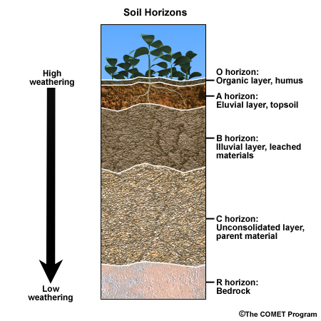
Soil formation is the result of many natural processes. Soils typically develop such that the top layers show the greatest impact of vegetation and weathering (the O and A horizons) while the bottom layers (the C horizon) have the least influence from plants and weathering.
Climate is the most influential factor in soil formation as it directly affects the weathering of source material and is critical for biological activity.
Other natural influences of soil formation include vegetation type and patterns, the local geology, biological activity, mineral reactions, and watershed topography. These will affect how much rainfall or snowmelt will enter the soil and how it will move or get stored within the soil.
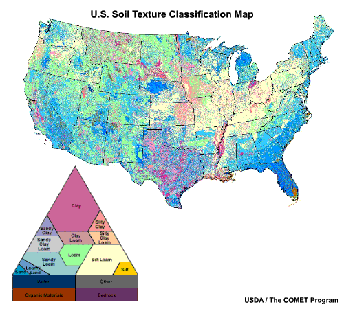
Soil Texture Classification
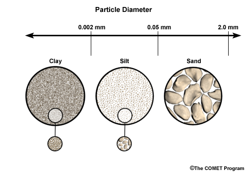
Soil texture is classified according to particle size. Clay has the smallest particle and pore space size, followed by silt, and then by sand with the largest size particles. Soil texture is very important for anticipating the potential infiltration, movement, and storage of soil water.
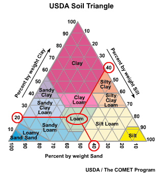
The USDA soil triangle is a reference tool that allows you to classify the soil based on the composition of its textures. (2) For example, if you take a sample of soil and determine that it is roughly 40% silt, 40% sand, and 20% clay, then we can see that the soil classification is “Loam.”
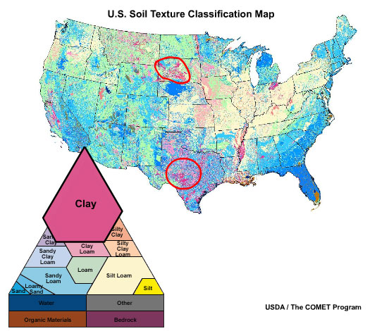
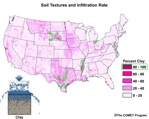
Note that the top of the triangle is dominated by clay soil textures that may be found in parts of Texas and the upper Missouri River basin.
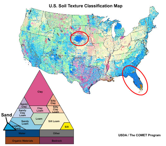
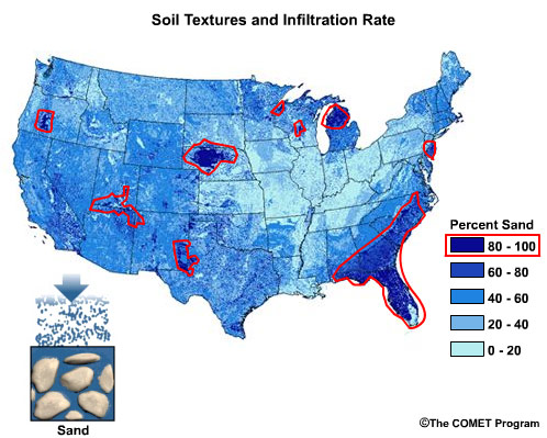
The bottom left of the triangle shows soils dominated by sand, found for example in the Nebraska sand hills or the Florida peninsula.
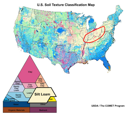
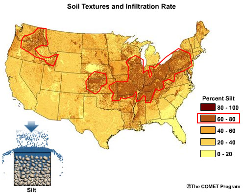
The bottom right of the triangle shows soils dominated by silt. A large part of the Ohio River basin is dominated by silt-loam soil texture.
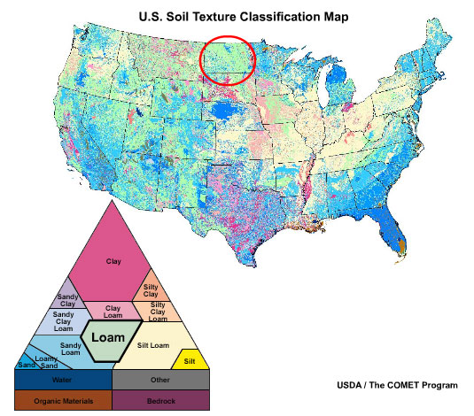
In the center of the triangle we see soils dominated by loam. We can see this texture classification in parts of the north-central United States.
Soil Composition
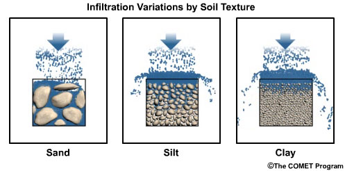
Soil may be composed of one or more types of soil textures. When soil contains a large percentage of sand, infiltration and drainage of water occurs more quickly because of the larger pore space. Such soil can absorb relatively high rates of rainfall or snowmelt.
Soils with a relatively high percentage of clay will have smaller pore space and correspondingly lower infiltration rates. Therefore, soils dominated by clay are less capable of absorbing high rainfall rates.
Silt has a particle size between sand and clay. Soils with a high percentage of silt will have higher infiltration and drainage rates than clay, but not as high as sand.
Click the image above to view animation.
Consequently, clay soils may result in greater surface runoff than sandy or silty soil during intense rainfall or rapid snowmelt. Sandy soil will generally produce the least surface runoff.
Soil texture information can assist with anticipating potential water storage and runoff. Keep in mind, of course, that it is still important to consider specifics of the situation such as soil moisture content and the rate of rainfall or snowmelt.
Click the image above to view animation.
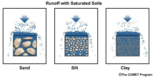
For example, if the soil is saturated as shown here, surface runoff will occur regardless of the soil texture.
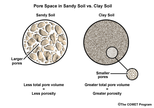
Although it may seem counter-intuitive, the small pore spaces of clay add up to more total void space than the fewer number of large pore spaces in sand. Consequently, in light rain or slow snowmelt, clay may be able to hold more water than sand.
Click the image above to view animation.
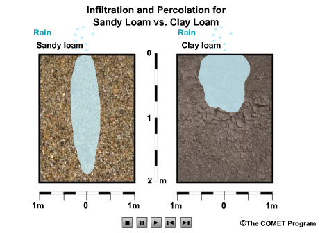
However, water drains from clay soil more slowly than from sandy soils. So in successive rain events, clay soils may remain saturated between storms and therefore produce more runoff in the later rain events.
Soil Profile
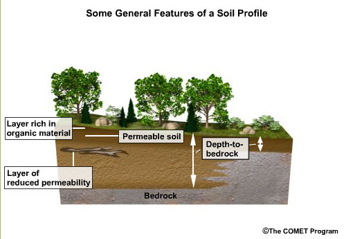
The soil profile provides information about the depth to bedrock as well as discontinuities in soil characteristics. Discontinuities include, among other things, vertical changes in soil properties and permeability.
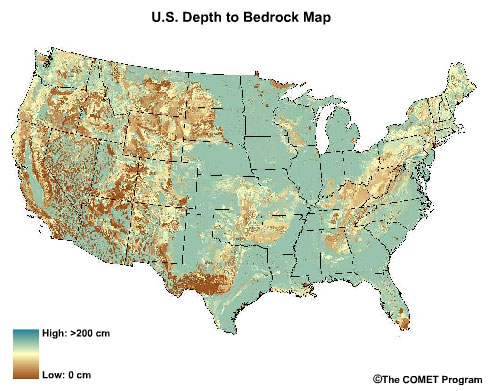
In the U.S. the depth to bedrock can vary widely. There are large areas with a soil depth of at least 200 centimeters, in parts of the Mississippi River valley, the Great Plains, and southeastern coastal areas. By contrast, soil depth in other areas is less than 25 centimeters. Mountainous and arid regions are more likely to have areas with shallow soil depth.
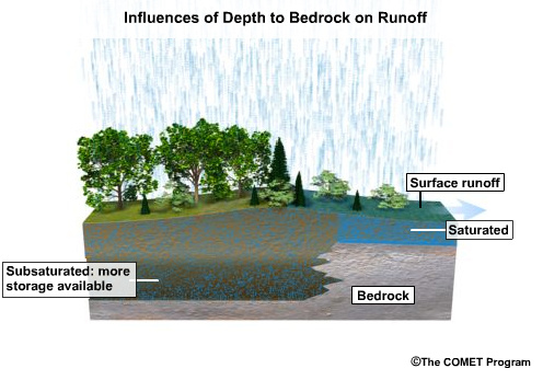
In general, areas with deep soil depth will have greater capacity to absorb and store water. These areas will likely have more interflow as well. By contrast, shallow soil areas typically saturate faster and produce more runoff given the same soil and rainfall conditions.
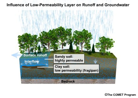
Another important characteristic of the soil profile is whether there are impermeable or low-permeable layers within the profile (also know as a fragipan). For example, consider a low-permeable layer of clay and rock beneath a surface layer of sandy soil. Rainfall or snowmelt in this area may rapidly infiltrate into the top sand layer, but only very slowly percolate through the more impermeable layer in the profile. This can result in both enhanced runoff and interflow in this area.
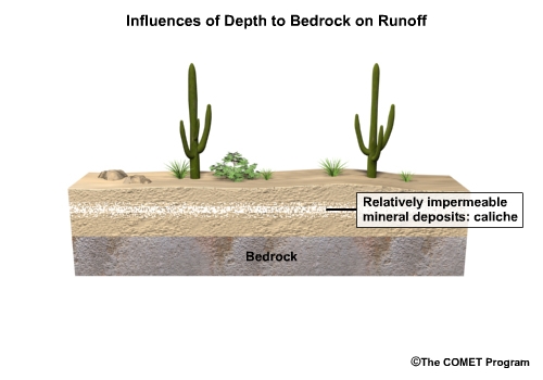
In some areas, mineral reactions result in relatively impermeable layers of calcium carbonate deposits known as caliche.
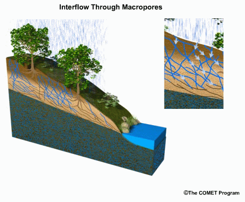
Finally, biologic and chemical activity in the soil can leave macropores. Recall that these natural pipes and void spaces enhance both the speed and the volume of water that can move vertically and horizontally through the soil profile.
Surface Properties
Soil surface properties can be the most important influence on runoff in some areas. If water is unable to infiltrate the soil surface, the characteristics of the soil profile below become unimportant. Impermeable surface materials, soil compaction, deforestation, and fire are factors that affect infiltration into the soil profile.
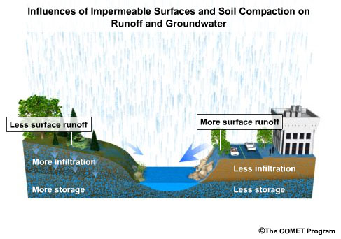
Covering ground surfaces with impermeable materials such as concrete and asphalt means less water can infiltrate. In addition, as soil becomes more compacted, the infiltration, percolation, and soil moisture storage all decrease. In general, human activity results in less infiltration, less storage, and greater surface runoff.
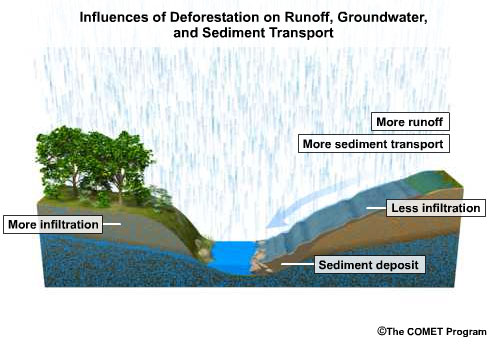
Deforestation can have an impact on infiltration and runoff. Without plant matter on the surface, water will move more quickly. This means water will have less time to infiltrate the soil. In addition, runoff from deforested areas is likely to contain more sediment. The sediment load can take up space in the stream channel that would otherwise be available for increased flow. Thus, deforested areas are more likely to result in enhanced runoff with large sediment loading into the stream channels.
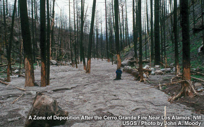
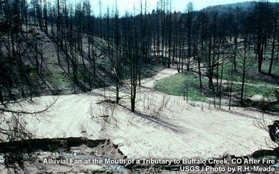
Fires are a type of deforestation that can have more severe consequences on subsequent runoff. In addition to the typical deforestation problems, fires can alter the soil surface and make it temporarily hydrophobic, that is, unable to absorb water. This is especially noted in pine forest areas because the oils and resins from the trees vaporize and get infused into the soil. This creates a hydrophobic layer at or near the surface. The severity of runoff and sediment loading can often be seen by the scour on the tree trunks and the alluvial deposits left after the floodwater passes.
Review Questions:
1. Compared to sandy soils, clay soils are more likely to _____.
(Choose all that apply.)
a) produce more runoff during extended periods of light rain
b) produce more runoff during intense thunderstorms
c) stay wet for longer after a rainfall
e) hold less volume of water when saturated
2. Infiltration excess overland flow is more likely during intense rainfall with _____.
(Choose the best answer.)
a) clay
b) silt
c) sand
e) loam
3. Saturation of the soil profile occurs more quickly with _____.
(Choose all that apply.)
a) shallow depth to bedrock
b) urbanization
c) a fragipan at shallow depths
d) large depth to bedrock
4. Deforestation does not generally result in _____.
(Choose the best answer.)
a) more surface runoff
b) more flood risk
c) more sediment transport
d) more infiltration
Review Question Feedback
1. Compared to sandy soils, clay soils are more likely to _____.
(Choose all that apply.)
The correct answers are b) produce more runoff during intense thunderstorms and c) stay wet for longer after a rainfall .
2. Infiltration excess overland flow is more likely during intense rainfall with _____.
(Choose the best answer.)
The correct answer is a) clay.
3. Saturation of the soil profile occurs more quickly with _____.
(Choose all that apply.)
The correct answers are a) shallow depth to bedrock and c) a fragipan at shallow depths.
4. Deforestation does not generally result in _____.
(Choose the best answer.)
The correct answer is d) more infiltration .
End of Section Four:
Soil Properties