
Detection
A Bounded Weak Echo Region (BWER) is a nearly vertical channel of weak radar echo, surrounded on the sides and top by significantly stronger echo. The BWER, sometimes called a vault, is related to the strong updraft in a severe convective storm that carries newly formed hydrometeors to high levels before they can grow to radar-detectable sizes. BWERs are typically found at midlevels of convective storms, 3-10 km above the ground, and are up to a few kilometres in diameter.
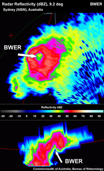
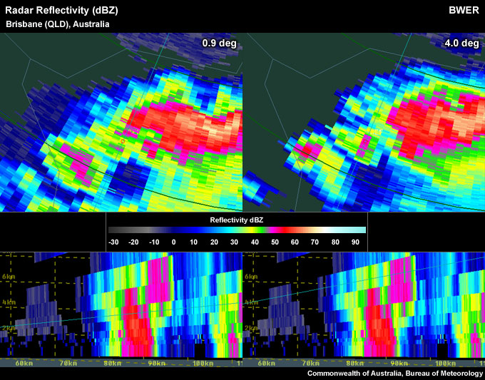
A "classic" BWER located in the centre of the ring shape in the PPI; a "grim reaper" shape representing the BWER in the RHI.
To detect a BWER signature use the following techniques:
Reflectivity: PPI/Plan View
Determining the updraft location:
- Step up in PPI elevation scans until you run out of >50 dBZ echoes.
- Step down one elevation scan.
- Centre cursor on the upshear side of >50 dBZ core (this is to account for storm movement and a slight storm top displacement during the time that elapsed between the lowest scan and storm top-level scan in the presence of strong winds aloft).
- Set a reference point.
- Step down through the elevations.
- Is there evidence of a doughnut or ring-shaped weak reflectivity echo at any elevation, particularly the midlevels (approximately 2-6 km above the ground) in the vicinity of the reference point?
Note: The doughnut or ring shape does not have to be a "closed loop".
If yes, a BWER is present. Otherwise, it might be easier to view the BWER with a cross section.
Note also that storms containing a BWER are almost always supercells, so confirmatory evidence can be obtained by looking for a mesocyclone signature (or at least cyclonic shear) surrounding the midlevel BWER.
Reflectivity: RHI/Cross-Section
Determining the updraft location:
- Step up in elevation scans until you run out of >50 dBZ echoes.
- Step down one elevation scan.
- Centre cursor on the upshear side of >50 dBZ core. (this is to account for storm movement and a slight storm top displacement during the time that elapsed between the lowest scan and storm top-level scan in the presence of strong winds aloft).
- Step down to the lowest elevation scan.
- Choose the most direct cross section from the reflectivity core at the lowest tilt (which should exhibit a strong reflectivity gradient) to the reference point you set in the upper levels, representing the storm top (see figure below).
Note: You may need to use an "arbitrary" (rather than radial) cross section if the storm top marker and the nearest low-level core are not oriented along a radial that originates at the radar location.
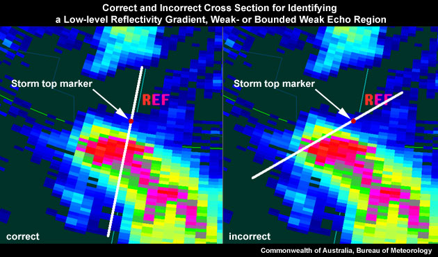
On the left is a correctly placed cross section for identifying a BWER, as the most direct path from the low level reflectivity core to the location of the storm top marker. On the right is an example of a badly placed cross section.
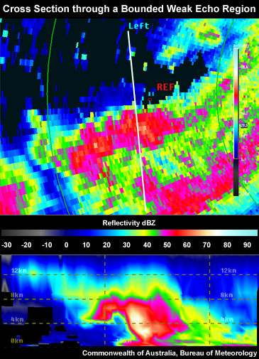
- Is there an area of weak echoes bounded by strong echoes above and on both sides? If yes, a BWER is present.
Potential Difficulties in Detection
- Low-topped storms – If low equilibrium level (this is often the tropopause) is present, the thunderstorm is low-topped and vertically compressing the BWER signature making it difficult to detect. This may be a particularly serious issue far away from the radar.
- Radar sampling:
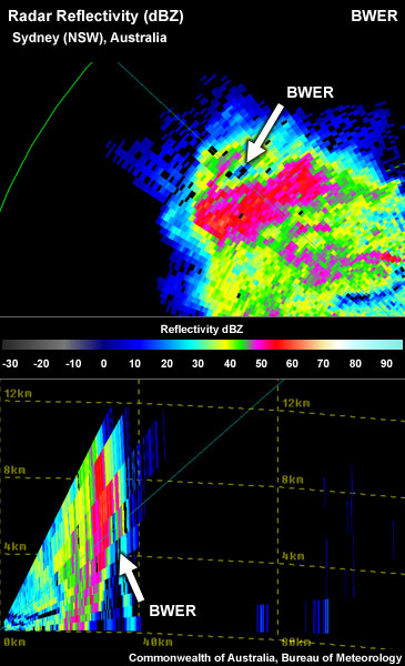
- Radar not aligned well with the storm. The radial from the radar does not allow a direct line from the storm top to the low-level core. An "arbitrary" (non-radial) cross-section needs to be used, which is an interpolated RHI with smoothed data.
Arbitrary (non-radial) cross section through a Bounded Weak Echo Region showing interpolated data.
-
- Resolution degradation as range increases – radar sampling degrades as averaging takes place across a broader and broader beam. This process smoothes out extreme reflectivity or velocity values, weakening or washing out the signature.
- The thunderstorm is too far away from the radar – therefore the radar beam overshoots the BWER.
- The thunderstorm is too close to the radar – therefore the radar undershoots the BWER (BWER "hides" inside "cone of silence").
Examples of Bounded Weak Echo Regions
A "classic" BWER located in the centre of the ring shape in the PPI; a "grim reaper" shape representing the BWER in the RHI. Note: Most BWER signatures are not this obvious.
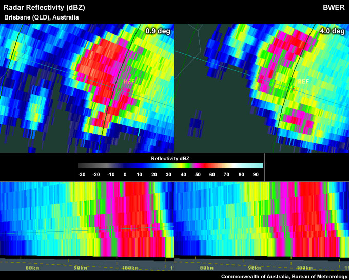
BWER seems not "closed off" on the NE side in the PPI despite ~40-45 dBZ pixels; "grim reaper" shape in RHI. Whether a BWER appears closed off or not in the PPI view depends strongly on the colour palette used in the display of reflectivity data. A minor shift (a few dBZ) of the dBZ threshold value where the reddish colours start could lead to the BWER closing off.
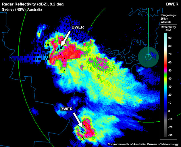
Two BWERs captured in the PPI, as part of a splitting pair of supercells. Both BWERs are not classic "closed" loops.
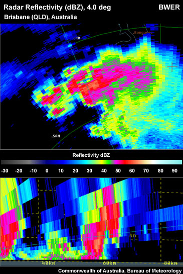
BWER on the northern flank of a severe storm.
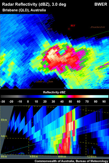
Nearly "closed" loop around BWER in PPI.
Bounded Weak Echo Region Look-a-Likes
The following signatures look like BWERs, but aren’t.
- Apparent signature is not on the updraft/inflow side of the storm. A BWER is the centre of the intense updraft. A BWER-like signature must be a “look-a-like” if no updraft echo on radar can be found co-located with the signature. This problem can be avoided if you use the detection method explained above.
Left panel: Cross section placed through a broken low-level core shows a BWER-like signature.
Right panel: Location of the RHI BWER look-alike signature is not near any of the storm tops which are located to the northeast and southeast.
- Elevated core from a separate updraft – more often than not storms are multicellular in nature with several updrafts located in close proximity to each other. Sometimes this can lead to confusion while interrogating storms, connecting elevated cores that are slightly displaced from the low-level core and assuming it forms one core with a BWER.
Left panel: PPI slice at ~4.2km ARL through the western edge of a substantial echo shows a BWER-like signature in the RHI display.
Right panel: A PPI slice around 7.1 km ARL shows that the "echo overhang" component of the pseudo-BWER signature in the RHI display actually belongs to a separate updraft along the southwestern flank of the major echo.
- Overspreading anvil – this should rarely be confused with a BWER, as anvils tend to have weaker reflectivities, than those often found within potentially severe thunderstorm cores.