
Conceptual Model
A Bounded Weak Echo Region (BWER) is used as one of many signatures suggesting a severe thunderstorm. The presence of a BWER indicates the thunderstorm possesses an intense updraft. A deep, persistent BWER is often associated with the presence of a mesocyclone, as BWERs are almost always associated with supercells. Note, however, that the BWER is not a product of storm-scale rotation centred on the weak echo "hole" that marks the centre of the BWER. It is the intense updraft within the BWER that prevents echo descent from above or echo development within. The BWER itself outlines the most intense core of the updraft. On the flanks of this intense updraft, large amounts of supercooled liquid water and growing hail form the sheath of high reflectivity surrounding the BWER itself. The hail, graupel, and rain also descend both downshear and upshear of the updraft, creating a bounded weak echo region within the sloping echo overhang. It is important to note that precipitation has been forced upshear, often into strong upper-level flow, creating the surrounding echo overhang, and weak echoes below indicating the intense updraft.
Persistent BWERs, as reasonably reliable proxies for supercells, suggest that the storm is capable of producing damaging winds, large hail and, on occasion, tornadoes. If some additional evidence confirms the presence of a supercell, destructive winds and giant hail should be considered. Flash flooding is not an automatic hazard associated with supercells, in particular for smaller or faster-moving storms. Supercells tend to have a comparatively low precipitation efficiency, but also process inordinate amounts of water vapour. The result of these two opposing drivers for heavy rainfall is that flash flooding is more likely with larger and/or slower-moving supercells. A climatology performed in the US in 2007 confirmed that supercells produce severe weather more frequently than other storm types, and also produce more intense severe weather (Duda & Gallus, 2010). An assessment of the likely tornado threat requires an inspection of the near storm environment (NSE) for suitable low-level and LCL values (see "Low-level Mesocyclone" signature) and the presence of low-level convergence/rotation on radar.
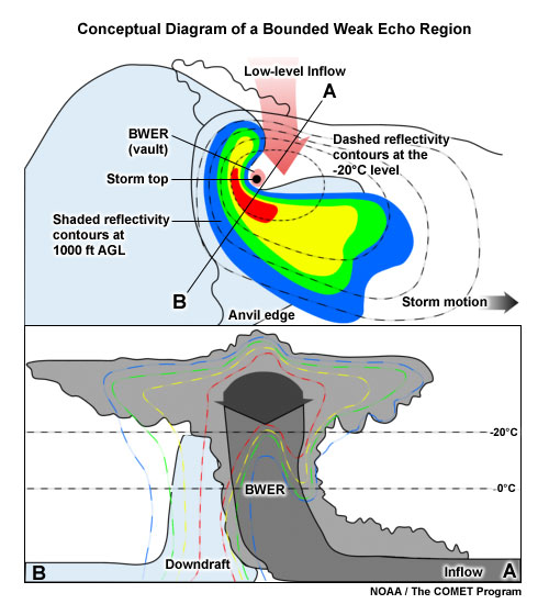
A conceptual model of the structure of a BWER within a thunderstorm. The top image shows a plan view of the storm at low level (shaded reflectivity contours) and the -20°C level (dashed reflectivity contours). The red arrow represents the inflow. The lower image shows a cross section of the storm, with the reflectivity contours dashed. The grey arrows represent the updraft with the blue shaded region the downdraft.
Determining Thunderstorm Classification
A persistent Bounded Weak Echo Region is almost always associated with supercell thunderstorms. For further confirmation, look for the existence of a mesocyclone or at least cyclonic shear with the BWER. To help determine or confirm the classification of the thunderstorm you are observing, use the following flow chart to help diagnose which thunderstorm conceptual model you should consider more closely.

See Supercell for more information.