
Conceptual Model
A Low-Level Mesocyclone is usable as a defining radar signature for a supercell thunderstorm. The presence of a Low-Level Mesocyclone indicates small-scale rotation usually located near the interface between the Rear-Flank Downdraft (RFD) and the low-level updraft. This rotational flow is associated with the presence of vertical vorticity which has been created through tilting of ambient horizontal vorticity near the RFD gust front and subsequent stretching. The vorticity is enriched along the RFD gust front and, at least in part, generated by horizontal gradients in low-level buoyancy. The horizontal vorticity, once tilted by a strong low-level convective updraft, is subsequently stretched due to accelerating parcels in the same updraft.
A persistent Low-Level Mesocyclone signature indicates a strong and reasonably steady updraft associated with a supercell. Supercells generally can produce all four severe convective hazards used to define a severe thunderstorm in Australia (large hail, damaging winds, tornadoes and flash flooding). Many studies since the 1970s, including a more recent climatology in the United States on events that took place in 2007 (Duda and Gallus, 2010) conclude that supercells produce severe weather far more frequently than other storm morphologies, and also produce more intense severe weather.
An idealised depiction of a symmetric mesocyclone as it would appear in the velocity channel of a Doppler radar is shown in the figure below.
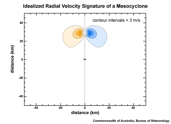
Idealised symmetric cyclonic (southern hemisphere) mesocyclone. The x and y axes show distance (km) from a radar origin at (0,0), and the radial velocity contour intervals are 3 ms-1.
The presence of a Low-Level Mesocyclone, especially when embedded in a storm environment of large 0-1km shear and high boundary layer relative humidity, is a significant predictor for supercell tornadogenesis. Trapp et al. (2005) found in their case sample that ~40% of low-level mesocyclone detections were tornadic. Other studies found that ~20% of supercells with low-level mesocyclones produce tornadoes.
In terms of tornadogenesis potential, the appearance of a low-level mesocyclone as a proxy for such potential should involve the consideration of the near-storm environment. Favourable environmental ingredients to support low-level tornadogenesis are large 0-1km shear (especially directional shear), good 0-1km CAPE and a high relative humidity boundary layer to prevent the rear flank downdraft cooling through evaporation/sublimation (Thompson et al. 2003; Craven and Brooks 2002).
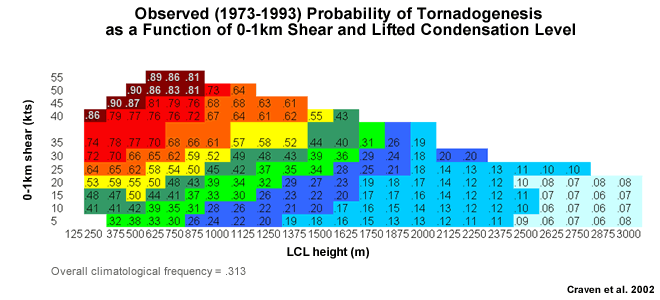
Probability of tornadogenesis as a function of two storm-environmental parameters: the 0-1 km shear and the height of the Lifted Condensation Level (LCL). Only 1800 LST soundings were used in the underlying climatology of Craven et al. (2002).
Determining Thunderstorm Classification
A significant, persistent Low Level Mesocyclone is associated with a supercell thunderstorm. To help determine or confirm the classification of the thunderstorm you are observing, use the following flow chart to help diagnose which thunderstorm conceptual model you should consider more closely.

See Supercell for more information.