
Diagnosis
Once you have identified the Three Body Scatter Spike (TBSS) radar signature with some confidence, this section will help you estimate the storm severity associated with it. Generally, the spatial and temporal scales of a signature are loosely related to the updraft strength. In other words, the larger and/or more long–lived the signature, the stronger the updraft that produced it. In velocity-based signatures, updraft severity can usually also be gauged by the magnitude of the measured radial velocities. Examining a storm's overall temporal evolution will suggest whether the storm is becoming more or less severe. Radar signatures and associated storm developments can also be time-shifted relative to each other, as is the case in supercell tornadoes that occur during the collapse of the parent storm.
When comparing signatures to diagnose relative severity, keep in mind that it is assumed that signatures are sampled at equal ranges from the radar. Otherwise, a storm sampled at greater range (with a wider beam) can appear to be weak and/or weakening, while a storm sampled at a closer range (with a narrower beam) can appear to be strong and/or strengthening.
Degree of Severity
Using an S-band radar, the TBSS signature is one of the few radar signatures that, if present, does not require any further interrogation to determine storm severity. If the signature is evident, a severe thunderstorm warning should be strongly considered. The TBSS is a sufficient but not necessary condition for large hail identification. Of course, it should not be concluded that storms producing the artifact, especially the shorter and less obvious signatures, will or are now, with absolute certainty, producing very large hail that will fall to the ground. While large hail or very large quantities of hail aloft are indicated with certainty, significant melting can occur during descent to the surface (Lemon, 1998).
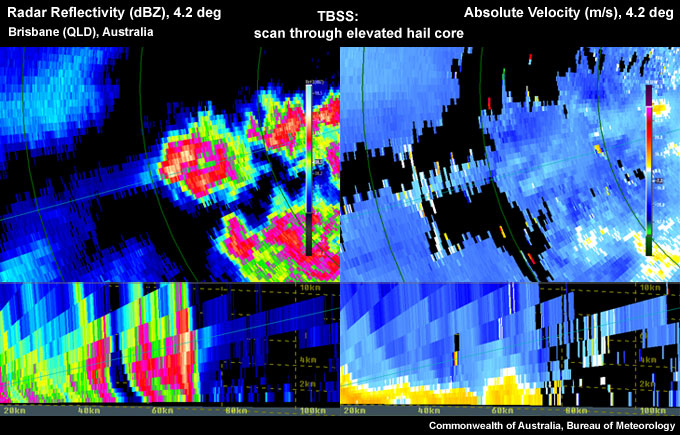
Pronounced TBSS evident downrange of the storm in both reflectivity and velocity fields.
The strength and length of the TBSS is related to the intensity and vertical extent of the reflectivity core. Therefore a TBSS should be easier to detect with a more intense, elevated reflectivity core. As the intensity and length of the TBSS is related to the intensity of the core, it is also a function of the hail size and perhaps hail density. In cases with a pronounced TBSS signature, hail >5 cm in diameter should be anticipated. When the most pronounced TBSS is occurring, vertically integrated liquids (VILs) are often very high or increasing. High values of VIL and a pronounced TBSS very often precede large surface hail. A TBSS has a predictive value in that it often develops during the hail growth phase aloft before very large hail forms; very strong winds may occur with the most striking TBSS signatures. Forecasters should anticipate hail equal to or greater than 2.5cm in diameter will reach the surface within the next 10-30 minutes (Lemon, 1998).
The longevity of the TBSS should be considered as a longer-lived TBSS requires a strong and steady updraft to create large hail aloft for long periods of time.
Although this signature does not require the backup of other radar signatures to determine storm severity, radar signatures should always be considered in conjunction with the near storm environment and any reports.
Most Likely Convective Hazards
If a thunderstorm has been determined to be severe and does possess a TBSS, large hail is highly likely. Damaging winds should also be strongly considered to be included on the warning.
See Conceptual Models for more details on why particular severe weather should be included.