
Conceptual Model
A Three-Body Scatter Spike (TBSS) is used as one of many signatures suggesting a severe thunderstorm. The presence of a TBSS on a S-band radar is a direct indication that the thunderstorm possesses large hail (see Lemon, 1998).
During the TBSS generation, the radar beam encounters hydrometeors that are large compared to the radar wavelength. In the case of large hail, instead of the common isotropic Rayleigh scattering of the beam energy, the beam is scattered more directionally (mainly forward: Mie Scattering) when large hydrometeors are observed (Fig. 1). Some of that energy is then scattered back from the often wet ground to the same hail core where it is forward-scattered back to radar antenna. This technique can only be used on S-band radars as on C-band radars the TBSS can be related to large raindrops rather than hail. The TBSS is a sufficient, but not necessary condition for large hail detection (Lemon , 1998).
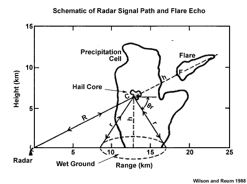
Fig.1 Schematic of the radar signal path responsible for the Three-Body Scatter Spike (flare echo).
This signature is strongest in the mid-levels as strength and length of the TBSS is related to the intensity and the height of the reflectivity core (Lemon 1998). Most storm cores contain the largest hailstones in the midlevels as the ideal hail growth layer is between -10°C and -30°C. As the hailstone descends through the atmosphere, the temperature of the environment increases and the hailstone should remain constant in size (or maybe grow a little) until it passes through the freezing level. This is the altitude at which the hail is the largest while also having developed a liquid coat of water, therefore producing the largest radar targets so that the TBSS is the most pronounced.
Lemon (1998) claims that surface hail of at least 2.5 cm in diameter should be expected when a TBSS is observed on S-band radar, often with a warning lead time of 10-30 minutes (Lemon, 1998).
Large hail is the most likely severe weather expected, but damaging winds should at least be considered, purely due to the fact a strong updraft is required to produce large hail. Lemon (1998) found that all but one of the TBSS storms examined in detail in this study were also known to have produced damaging surface winds. This research is consistent with the findings in Ohno (1994), stating that the most damaging microburst winds in Japan are almost exclusively associated with hail producing storms.
Determining Thunderstorm Classification
A TBSS is usually associated with supercell thunderstorms. To help determine the classification of the thunderstorm you are observing, use the following flow chart to help diagnose which thunderstorm conceptual model you should consider more closely.

See Supercell for more information.