«- back to print version table of contents
Hook Echo
Detection
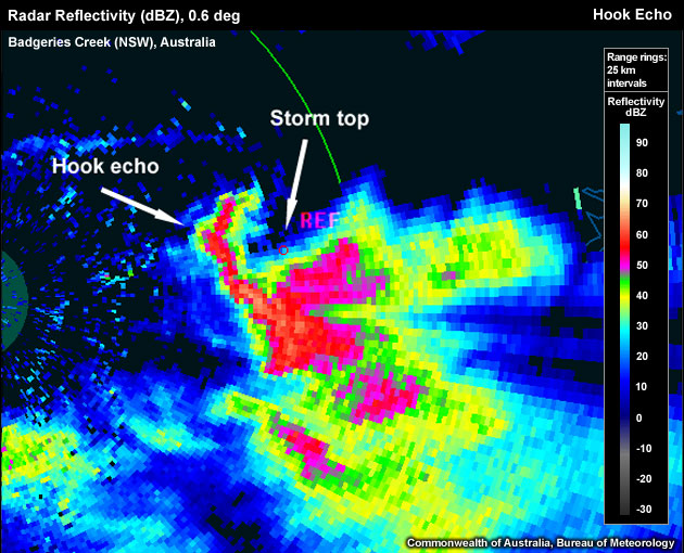
A Hook Echo signature is usually a hook-like appendage to the low-level radar reflectivity echo of a supercell. The Hook Echo is located in the vicinity of the updraft, typically on the left-rear flank of cyclonic storms in the southern hemisphere, underneath a sloping echo overhang and below the storms echo top. Hook Echoes may possess a classic "hook shape", but depending on the point in the lifecycle captured by the radar volume scan and radar resolution, they may appear as an "appendage" or "pendant" (see figure below). The Hook Echo forms when precipitation descends from higher levels behind the storm's main updraft (similar to hydrometerors descending within the upshear branch of a Bounded Weak Echo Region). Most, if not all Hook Echoes are associated with supercells in which the descending precipitation is often entrained into the circulation of the storm's mesocylone. In some cases this also leads to spiral-shaped Hook Echoes at low levels.
A Hook Echo wrapping around the updraft in the low-level volume scan.
To determine if the signature you are seeing is a Hook Echo use the following technique:
Reflectivity: PPI/Plan View
- Step up in elevation scans until you run out of >50 dBZ echoes.
- Step down one elevation scan.
- Centre cursor on the upshear side of >50 dBZ core (this is to account for storm movement and strong winds aloft which leads to echo translation between the lowest- and the storm top-level scans).
- Set a reference point.
- Step down to the lowest elevation scan. This reference point should be the location of your updraft.
- Is there a "pendant" or "hook" shaped echo wrapping around the updraft (the location of the reference point)? If so, a Hook Echo or developing Hook Echo may be present.
A rather long Hook Echo wrapping around the low-level circulation of a storm in the low-level PPI scan.
For confirmation of the presence of a true Hook Echo, switching to the velocity field may show a low-level mesocyclone. Note: Sometimes Hook Echoes form before a low-level mesocyclone is evident on radar. Check higher elevations for a mid-level mesocyclone. Also, a Hook Echo has been postulated as being the low-level reflection of the upshear branch of a Bounded Weak Echo Region, so check for a Bounded Weak Echo Region above the suspected Hook Echo signature.
Potential Difficulties in Detection
- Close proximity to other storms - The nearby storms may affect the detection of the signature.
- Radar sampling:
- The thunderstorm is too far away from the radar. This can affect the detection in 2 ways:
- Far from the radar, the individual pixels represent a much larger area. This can then make a small or developing Hook Echo difficult to diagnose due to the smoothed data.
- The radar overshoots the low-level signature
- Attenuation, especially with C-band radars - If the Hook Echo is located on the far side of the thunderstorm, and the radar beam must pass through a substantial core to reach the Hook Echo, the signature may be washed out.
- The thunderstorm is too far away from the radar. This can affect the detection in 2 ways:
Examples of Hook Echoes
Use the radio buttons or click the image to switch between reflectivity and velocity imagery:
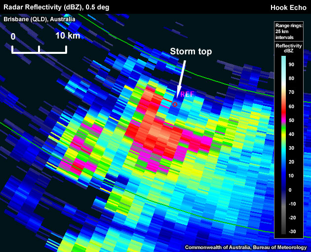
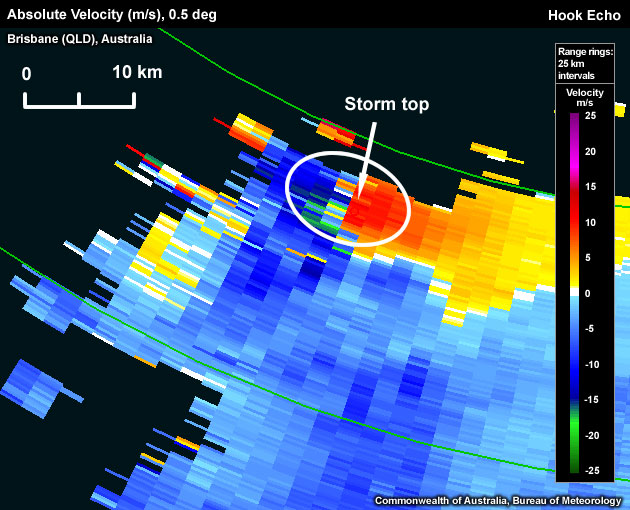
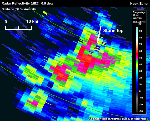
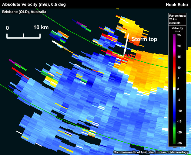
"Broad" hook, evident in the reflectivity, co-located with a broad low-level mesocyclone (oval) seen in the velocity field at the same elevation.
Use the radio buttons or click the image to switch between reflectivity and velocity imagery:
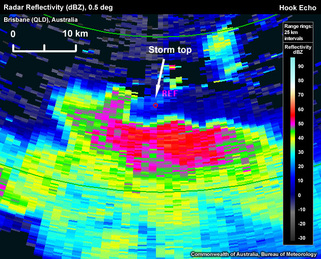
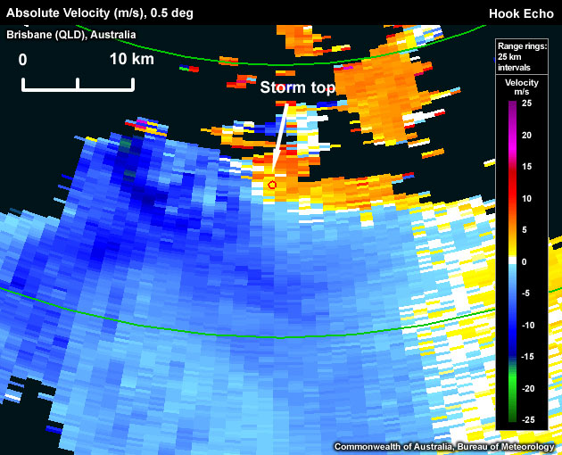
Hook Echo embedded within the inbound branch of a low-level mesocyclone. The mesocyclone centre is located to the east of the hook.
Use the radio buttons or click the image to switch between reflectivity and velocity imagery:
Hook echo co-located with a low-level mesocyclone.
Use the radio buttons or click the image to switch between reflectivity and velocity imagery:
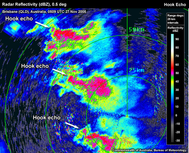
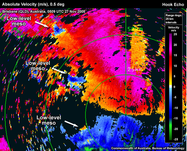
Three supercells with Hook Echoes co-located with low-level mesocyclones.
Hook Echo Look-a-Likes
The Hook Echo is one of the most commonly misdiagnosed severe thunderstorm signatures! Thunderstorms often produce a "tail" shaped echo, which is often mistaken for a developing Hook Echo. Understand the following look-a-like traps to help correctly diagnose the Hook Echo signature.
- Incorrect storm relative location - The easiest way to confirm that a reflectivity appendage might indeed be a Hook Echo is by noting the location of the echo. The Hook Echo must be collocated with the updraft and, usually, low-level rotation, or at least associated with mid-level rotation. There are a number of reasons why the storm produces reflectivity appendages, such as a multicellular storm with close proximity of the "flanking line" of developing cumulus towers or updraft cores.
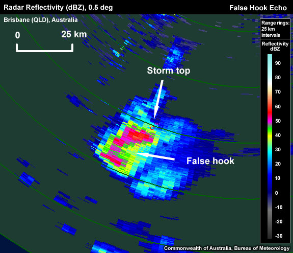
Low-level hook shape on southern side of storm, whereas the updraft/storm top is on the northern side of the storm. False hook signature on the southern flank.
- Incorrect elevation scan - The Hook Echo is a primarily a low-level signature, so should not be detected solely at higher elevations.
Hook Echoes are essentially a supercell signature. To confirm that you are dealing with a supercell and anticipate its potential development and movement, see the Conceptual Model section.
Conceptual Model
A Hook Echo is used as one of many signatures suggesting a severe thunderstorm (usually a supercell). The presence of a Hook Echo often indicates the thunderstorm possesses a very strong, rotating updraft.
The Hook Echo is a well researched radar reflectivity signature, although the formation of the hook is still under investigation. Early research by Fujita (1958) hypothesized that the Hook Echo formed as precipitation was advected around a supercell's rotating updraft, though more recent research has shown the formation is not this simple. Hydrometeors fall relative to the ambient air, therefore Hook Echoes must involve descending precipitation curtains (Byko et. al., 2009). The latest theory involves a "descending reflectivity core (DRC)" at the rear of the weak-echo region (Rasmussen et.el., 2006). The descending precipitation occurs on the rear flank of the updraft and could be seen as a low-level "extension" of the Bounded Weak Echo Region (BWER) (Les Lemon, personal communication, 2010). Commonly, it is believed that the descending precipitation interacts with the storm's mesocyclone so that it is descending along an arc.
The presence of a Hook Echo suggests a supercellular thunderstorm. Supercells increase the chance of any of the four severe convective hazards occurring: damaging or destructive winds, large or giant hail, heavy rainfall resulting in flash flooding, and tornadoes. A common belief is that the presence of a Hook Echo also increases the chances of the thunderstorm producing a tornado, although now there are recent claims that Hook Echoes are no better at indicating a tornadic storm than the presence of a mesocyclone (Markowski, personal communication, 2010).
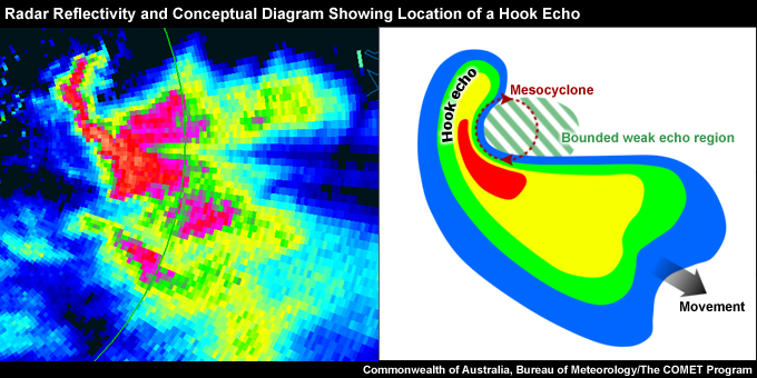
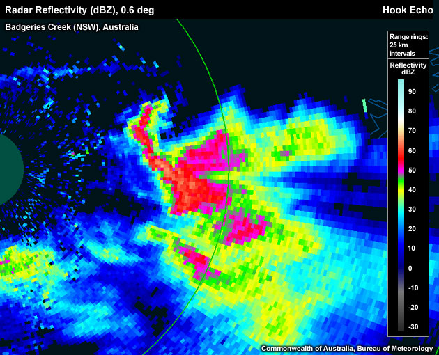
Radar reflectivity from Badgeries Creek (NSW), Australia, 0500 UTC 03 November 2000, compared to a conceptual image showing location of Hook Echo.
Determining Thunderstorm Classification
Hook Echoes are most associated with supercell thunderstorms. To help determine the classification of the thunderstorm you are observing, use the following flow chart to help diagnose which thunderstorm conceptual model you should consider more closely.

See Supercell for more information.
Diagnosis
Once you have confidently identified a "Hook Echo" signature, this section will help you estimate the storm severity associated with it. Generally, the spatial and temporal scales of a signature are loosely related to the updraft strength. In other words, the larger and/or more long–lived the signature, the stronger the updraft that produced it. In velocity-based signatures, updraft severity can usually also be gauged by the magnitude of the measured radial velocities. Examining a storm's overall temporal evolution will suggest whether the storm is becoming more or less severe. Radar signatures and associated storm developments can also be time-shifted relative to each other, as is the case in supercell tornadoes that occur during the collapse of the parent storm.
When comparing signatures to diagnose relative severity, keep in mind that it is assumed that signatures are sampled at equal ranges from the radar. Otherwise, a storm sampled at greater range (with a wider beam) can appear to be weak and/or weakening, while a storm sampled at a closer range (with a narrower beam) can appear to be strong and/or strengthening.
Degree of Severity
Longevity of the Hook Echo
- A persistent Hook Echo is a proxy for thunderstorm severity.
Time Evolution of Hook Echo Curvature
- Radar scans with high time resolution show that some Hook Echoes can complete part of or more than a full revolution around the low-level mesoscyclone, indicative of stronger low-level rotation in the presence of a supply of falling precipitation.
Considering all these aspects of a Hook Echo signature will help to determine overall whether you are dealing with a significant signature. A Hook Echo is one of the few signatures that could influence you directly into issuing a severe thunderstorm warning, based on the tight connection to a supercellular thunderstorm. Generally, radar information should never be used in isolation and should always be considered in conjunction with the near storm environment and any reports.
Most Likely Convective Hazards
If a thunderstorm has been determined to be severe and possesses a Hook Echo of significance, the following severe weather should be considered to be included in the severe thunderstorm warning:
- Damaging winds - A Hook Echo is a representation of a strong updraft, with potential to produce a strong downdraft. Destructive winds should be considered over damaging winds due to the supercellular classification.
- Large hail - A strong updraft has the potential to produce large hail as it is likely to supply plenty of supercooled liquid to the -10°C to -30°C hail growth layer.
- Heavy rainfall resulting in flash flooding - A particularly strong updraft has the potential to produce large amounts of precipitation, accumulating and falling as heavy rainfall resulting in flash flooding. For supercells, slower-moving and larger storms are more likely to produce flash flooding
- Tornado - Due to the indication the thunderstorm is supercellular, tornadoes are possible and therefore should be at least considered, especially in environments that combine high low-level relative humidity with strong 0-1km shear.
See Conceptual Models for more details on why particular severe weather should be included.
References/Addendum
Byko, Z. et. a., 2009: Descending Reflectivity Cores in Supercell Thunderstorms Observed by Mobile Radars and in a High-Resolution Numerical Simulation. Wea. Forecasting, 24, 155-186.
Fujita, T. T., 1958: Mesoanalysis of the Illinois tornadoes of 9 April 1953. J. Meteor., 15, 288-296.
Rasmussen, E. N. et.al., 2006. A preliminary survey of rear-flank descending reflectivity cores in supercell storms. Wea. Forecasting, 21, 923-938.