«- back to print version table of contents
Three-Body Scatter Spike
Detection
An S-band Three-Body Scatter Spike (TBSS), also known as a "hail flare" or "flare echo", is a 10-30 km long, low reflectivity (< 20 dBZ), mid-level echo "spike" aligned radially downrange from a high reflectivity (usually 63 dBZ+) core (Lemon, 1998). This echo spike is strictly an artifact of the electromagnetic radar beam being subject to "Mie scattering" instead of the usual "Rayleigh scattering" process.
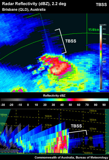
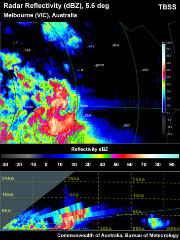
Thunderstorm on the reflectivity PPI and RHI showing Three-Body Scatter Spike (TBSS) downrange from an intense reflectivity core.
To determine if the signature you are seeing is a TBSS use the following technique:
Reflectivity: PPI/Plan View
- For S-band radars, step up and down in elevation, looking closely at the maximum reflectivity core, mainly in the midlevels (often at or colder than the freezing level), keeping a look out for a "flare" or "spike" downrange of the core. Note: It is best to have a good handle on the environmental temperature structure, as this signature should be strongest around 0 to -30°C.
- If the flare has weak reflectivities (<20 dBZ), is positioned downrange and along the same radar radial as the most intense part of the actual core, is almost exclusively aloft, and begins the same distance from the core as the core is above the ground, then a TBSS is present. Note that if the reflectivity increases at longer ranges along the potential TBSS, it is not a TBSS.
Note: TBSS signature is even more common with a C-band radar, but due to shorter radar wavelengths, we cannot deduce that large hail caused the TBSS signature.
Reflectivity: RHI/Cross-Section
S-band radars can also detect a TBSS in the cross section.
- Place a vertical cross section through the reflectivity core at the location where a local maximum in the reflectivity is present within the 0 to -30ºC layer.
- If the flare has weak reflectivities (<20 dBZ), is positioned downrange and along the same radar radial as the most intense part of the actual core, is almost exclusively aloft and begins the same distance from the core as the core is from the ground, then a TBSS is present.
Note: vertical cross sections must be precisely placed to reveal the critical storm features such as a TBSS, therefore they are less useful for real-time detection.
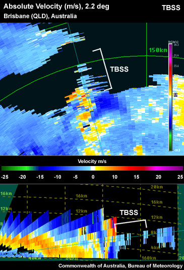
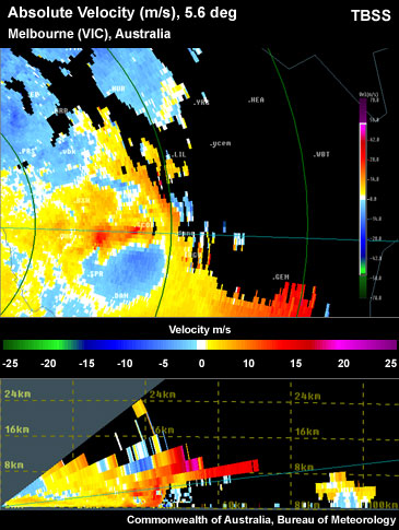
Thunderstorm on the absolute velocity PPI and RHI showing a Three-Body Scatter Spike (TBSS) artifact downrange of the storm reflectivity core.
Velocity PPI/Plan View
This method is probably the most difficult for the detection of a TBSS. It might be best used to confirm a TBSS determination utilising one of the previous methods.
- For S-band radars, step up and down in elevation, looking closely at the maximum reflectivity core, keeping a look out for a "flare" or "spike" in the reflectivity channel downrange from the core.
- If the flare has near zero or weak velocities, is positioned along the same radar radial, is almost exclusively aloft and is located the same distance from the core as the core is from the ground, then a TBSS is present.
Note: the most effective detection of a TBSS is via spectrum width.
The strength and length of the TBSS is related to the intensity and vertical extent of the reflectivity core. Therefore a TBSS should be easier to detect with a more intense and elevated reflectivity core. Also the larger the highly reflective core area, the more extensive the TBSS (Lemon, 1998).
Keep in mind this signature is an artifact artifact of Mie scattering and must not be construed as hail actually reaching the surface beneath the echo spike itself.
Potential Difficulties in Detection
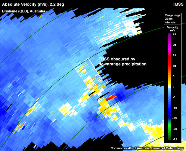
- Obscured echoes TBSS can be obscured by either separate downrange storms or by downrange precipitation from the same storm falling from a large anvil.
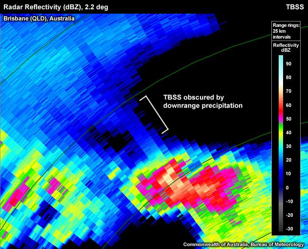
Three-Body Scatter Spike (TBSS) obscured by downrange precipitation from other storms.
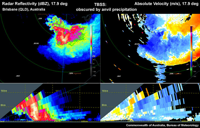
TBSS partially obscured by anvil precipitation in a PPI cross-section. Interestingly, the TBSS stands out more in the velocity signature than the reflectivity signature, especially in the PPI view.
- Hail core is close to ground There are two ways this affects the detection of a TBSS: one, the TBSS will begin immediately behind the echo core, and therefore may be obscured (as mentioned above) and two, the TBSS will be short in length, and therefore not stand out as much as a more pronounced TBSS from an elevated core.
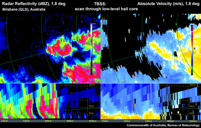
Scanning through the hail core close to the ground, the TBSS is short in appearance, especially in the PPI view.
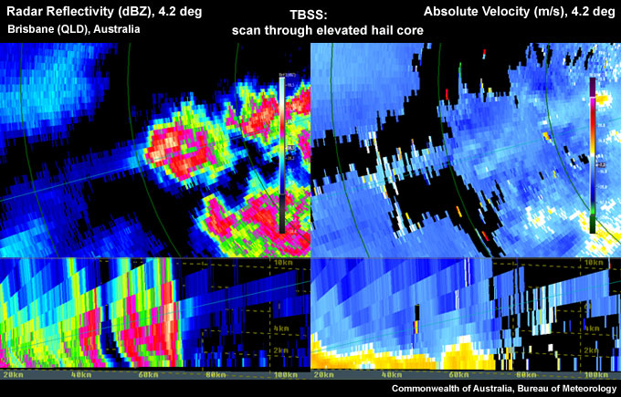
Looking at the same storm as in the previous figure, but scanning through the elevated hail core, the TBSS is longer; this is especially evident in the PPI view.
- Radar sampling:
- The thunderstorm is too far away from the radar – Therefore theradar beam overshoots the main hail core.
- The thunderstorm is too close to the radar – Therefore the radar cannot scan the storm in the mid-levels where the signature might have been detected.
- There is a large potential for second or third trip echoes to interfere with the detection of this signature.
Examples of Three-Body Scatter Spikes
Use the radio buttons or click the image to switch between reflectivity and velocity imagery:
Pronounced TBSS downrange of most intense part of the core in mid-levels. Note the steady decrease in intensity of the TBSS with range.
Use the radio buttons or click the image to switch between reflectivity and velocity imagery:
TBSS partially obscured by downrange precipitation.
Use the radio buttons or click the image to switch between reflectivity and velocity imagery:
Pronounced TBSS, due to the higher elevation of the hail core. Note the exaggerated echo top due to side lobe contamination which is sometimes seen with this signature.
TBSS Look-a-Likes
- TBSS located in the wrong position The TBSS should be located radially downrange from a high reflectivity core of approximately >63dBZ reflectivities.
- Actual precipitation/topography returns Light showers could be mistaken for a TBSS if they were in the correct position.
- Sun spike
Conceptual Model
A Three-Body Scatter Spike (TBSS) is used as one of many signatures suggesting a severe thunderstorm. The presence of a TBSS on a S-band radar is a direct indication that the thunderstorm possesses large hail (see Lemon, 1998).
During the TBSS generation, the radar beam encounters hydrometeors that are large compared to the radar wavelength. In the case of large hail, instead of the common isotropic Rayleigh scattering of the beam energy, the beam is scattered more directionally (mainly forward: Mie Scattering) when large hydrometeors are observed (Fig. 1). Some of that energy is then scattered back from the often wet ground to the same hail core where it is forward-scattered back to radar antenna. This technique can only be used on S-band radars as on C-band radars the TBSS can be related to large raindrops rather than hail. The TBSS is a sufficient, but not necessary condition for large hail detection (Lemon , 1998).
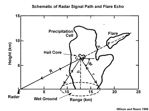
Fig.1 Schematic of the radar signal path responsible for the Three-Body Scatter Spike (flare echo).
This signature is strongest in the mid-levels as strength and length of the TBSS is related to the intensity and the height of the reflectivity core (Lemon 1998). Most storm cores contain the largest hailstones in the midlevels as the ideal hail growth layer is between -10°C and -30°C. As the hailstone descends through the atmosphere, the temperature of the environment increases and the hailstone should remain constant in size (or maybe grow a little) until it passes through the freezing level. This is the altitude at which the hail is the largest while also having developed a liquid coat of water, therefore producing the largest radar targets so that the TBSS is the most pronounced.
Lemon (1998) claims that surface hail of at least 2.5 cm in diameter should be expected when a TBSS is observed on S-band radar, often with a warning lead time of 10-30 minutes (Lemon, 1998).
Large hail is the most likely severe weather expected, but damaging winds should at least be considered, purely due to the fact a strong updraft is required to produce large hail. Lemon (1998) found that all but one of the TBSS storms examined in detail in this study were also known to have produced damaging surface winds. This research is consistent with the findings in Ohno (1994), stating that the most damaging microburst winds in Japan are almost exclusively associated with hail producing storms.
Determining Thunderstorm Classification
A TBSS is usually associated with supercell thunderstorms. To help determine the classification of the thunderstorm you are observing, use the following flow chart to help diagnose which thunderstorm conceptual model you should consider more closely.

See Supercell for more information.
Diagnosis
Once you have identified the Three Body Scatter Spike (TBSS) radar signature with some confidence, this section will help you estimate the storm severity associated with it. Generally, the spatial and temporal scales of a signature are loosely related to the updraft strength. In other words, the larger and/or more long–lived the signature, the stronger the updraft that produced it. In velocity-based signatures, updraft severity can usually also be gauged by the magnitude of the measured radial velocities. Examining a storm's overall temporal evolution will suggest whether the storm is becoming more or less severe. Radar signatures and associated storm developments can also be time-shifted relative to each other, as is the case in supercell tornadoes that occur during the collapse of the parent storm.
When comparing signatures to diagnose relative severity, keep in mind that it is assumed that signatures are sampled at equal ranges from the radar. Otherwise, a storm sampled at greater range (with a wider beam) can appear to be weak and/or weakening, while a storm sampled at a closer range (with a narrower beam) can appear to be strong and/or strengthening.
Degree of Severity
Using an S-band radar, the TBSS signature is one of the few radar signatures that, if present, does not require any further interrogation to determine storm severity. If the signature is evident, a severe thunderstorm warning should be strongly considered. The TBSS is a sufficient but not necessary condition for large hail identification. Of course, it should not be concluded that storms producing the artifact, especially the shorter and less obvious signatures, will or are now, with absolute certainty, producing very large hail that will fall to the ground. While large hail or very large quantities of hail aloft are indicated with certainty, significant melting can occur during descent to the surface (Lemon, 1998).
Pronounced TBSS evident downrange of the storm in both reflectivity and velocity fields.
The strength and length of the TBSS is related to the intensity and vertical extent of the reflectivity core. Therefore a TBSS should be easier to detect with a more intense, elevated reflectivity core. As the intensity and length of the TBSS is related to the intensity of the core, it is also a function of the hail size and perhaps hail density. In cases with a pronounced TBSS signature, hail >5 cm in diameter should be anticipated. When the most pronounced TBSS is occurring, vertically integrated liquids (VILs) are often very high or increasing. High values of VIL and a pronounced TBSS very often precede large surface hail. A TBSS has a predictive value in that it often develops during the hail growth phase aloft before very large hail forms; very strong winds may occur with the most striking TBSS signatures. Forecasters should anticipate hail equal to or greater than 2.5cm in diameter will reach the surface within the next 10-30 minutes (Lemon, 1998).
The longevity of the TBSS should be considered as a longer-lived TBSS requires a strong and steady updraft to create large hail aloft for long periods of time.
Although this signature does not require the backup of other radar signatures to determine storm severity, radar signatures should always be considered in conjunction with the near storm environment and any reports.
Most Likely Convective Hazards
If a thunderstorm has been determined to be severe and does possess a TBSS, large hail is highly likely. Damaging winds should also be strongly considered to be included on the warning.
See Conceptual Models for more details on why particular severe weather should be included.
References/Addendum
Lemon, L.R., 1998. The Radar "Three-Body Scatter Spike": An Operational Large-Hail Signature. Weather and Forecasting, 13, 327-340.
Ohno, H. et. al., 1994. Okayama downbursts on 27 June 1991: Downburst indentifications and environmental conditions. J. Meteor. Soc. Japan, 72, 197-222.
Wilson, J.W. & D. Reum, 1988. The Flare Echo: Reflectivity and Velocity Signature. Journal of Atmospheric and Oceanic Technology, 5, 197-205.
Zrnic, D.S., 1987. Three-body scattering produces precipitation signature of special diagnostic value. Radio Science,22, 76-86.