
Diagnosis
Once you have confidently identified a "tight low-level reflectivity" signature, this section will help you estimate the storm severity associated with it. Generally, the spatial and temporal scales of a signature are loosely related to the updraft strength. In other words, the larger and/or more long–lived the signature, the stronger the updraft that produced it. In velocity–based signatures, updraft severity can usually also be gauged by the magnitude of the measured radial velocities. Examining a storms overall temporal evolution will suggest whether the storm is becoming more or less severe. Radar signatures and associated storm developments can also be time–shifted relative to each other, as is the case in supercell tornadoes that occur during the collapse of the parent storm.
When comparing signatures to diagnose relative severity, keep in mind that it is assumed that signatures are sampled at equal ranges from the radar. Otherwise, a storm sampled at greater range (with a wider beam) can appear to be weak and/or weakening, while a storm sampled at a closer range (with a narrower beam) can appear to be strong and/or strengthening.
Degree of Severity
- Gradient strength – Larger changes in reflectivity over a specific distance (stronger gradients) typically indicate stronger updrafts. For example, a stronger updraft is required to size sort 70 dBZ radar targets, as opposed to only 50 dBZ targets.
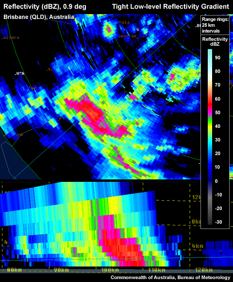
Weaker low-level reflectivity gradient on northern flank in PPI, left hand side in RHI.
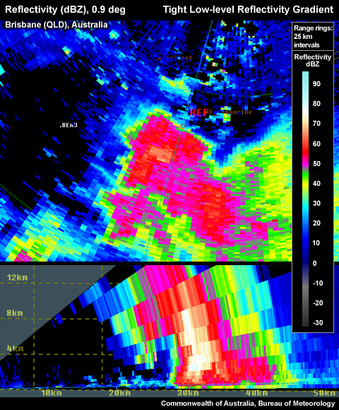
Very tight low-level reflectivity gradient on northern flank in PPI, left hand side in RHI.
- Longevity of the gradient – The more persistent the presence of the tight gradient, the more likely that the this thunderstorm is long–lived and able to continually feed the updraft with a strong inflow.
Considering all these aspects of a Tight Low-level Reflectivity Gradient signature will help to determine overall whether you are dealing with a significant reflectivity gradient signature. In the context of a severe thunderstorm warning decision, a very tight gradient should be counted as good evidence of a severe thunderstorm, but should be used in conjunction with other signatures. Radar data should never be used in isolation and should always be considered in conjunction with the nea- storm environmental information and any observer reports.
Most Likely Convective Hazards
- Damaging winds – a tight low-level reflectivity gradient is a representation of a strong updraft, with potential to produce a strong downdraft.
- Large hail – a strong updraft has the potential to produce large hail, providing the updraft extends past the freezing layer, to –10 to –30 °C layer. Some consideration of the temperature of the environment between the thunderstorm base and the ground is useful to identify the potential for hail melting on its descent to the ground.
See Conceptual Models for more details on why particular severe weather should be included.