
Diagnosis
Once you have confidently identified a Weak Echo Region signature, this section will help you estimate the storm severity associated with it. Generally, the spatial and temporal scales of a signature are loosely related to the updraft strength. In other words, the larger and/or more long–lived the signature, the stronger the updraft that produced it. In velocity-based signatures, updraft severity can usually also be gauged by the magnitude of the measured radial velocities. Examining a storms overall temporal evolution will suggest whether the storm is becoming more or less severe. Radar signatures and associated storm developments can also be time-shifted relative to each other, as is the case in supercell tornadoes that occur during the collapse of the parent storm.
When comparing signatures to diagnose relative severity, keep in mind that it is assumed that signatures are sampled at equal ranges from the radar. Otherwise, a storm sampled at greater range (with a wider beam) can appear to be weak and/or weakening, while a storm sampled at a closer range (with a narrower beam) can appear to be strong and/or strengthening.
Degree of Severity
- Horizontal length of WER – The larger the distance between the overhang of upper-level 50 dBZ core from low level 50 dBZ core, the more vigorous the flow divergence and hydrometeor suspension would have to be. An unpublished U.S. Radar Climatology compiled by Les Lemon suggests that the minimum overhang length for a severe thunderstorm was around 4 km. (Lemon, personal correspondence). Below are two different examples of overhang distances in severe thunderstorms.
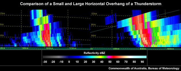
A comparatively small horizontal overhang of a thunderstorm core on the left and a comparatively large horizontal overhang of a thunderstorm core on the right.
- Longevity of the WER – The more persistent a WER, the more likely that the thunderstorm has persistently strong flow divergence. In that case, the storm would have a persistently strong updraft that allows hail embryos longer residence times in regions promoting hail growth, given that the updraft was embedded in the hail growth layer.
- Average dBZ of WER – The higher the average reflectivity in the core that shapes the WER, the larger the hydrometeors that are present, particularly large hail. The creation of large hydrometeors requires a strong updraft. For an updraft to be deemed strong, the suspended reflectivity values need to be at least 50 dBZ.
- Vertical depth of the WER – The larger the distance, H, between the ground and the main overhang aloft, the more likely the updraft summit divergence reaches into (or beyond) the ideal hail growth layer with supercooled liquid water droplets required for the production of large hail. Very tall WERs are more meaningful as an updraft strength proxy than short stubby ones, given both WERs are sampled equally by the radar and exist in the same storm environment.
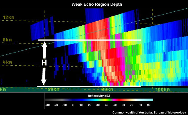
Weak Echo Region depth (H).
Considering all these aspects will help to determine overall whether you are dealing with a particularly significant WER signature. In the context of a severe thunderstorm warning decision, a significant WER should be counted as good evidence of a severe thunderstorm, but should be used in conjunction with other signatures and should always be considered in conjunction with near-storm environmental information and any severe weather reports.
Most Likely Convective Hazards
If a thunderstorm has been determined to be severe and possesses a WER of significance, the following severe weather should be considered to be included in the severe thunderstorm warning:
- Damaging winds – A WER is a representation of a strong updraft, with potential to produce a strong downdraft.
- Large hail – A strong updraft has the potential to produce large hail, providing the updraft extends into the hail growth layer (-10°C to -30°C). Consider the (wet bulb) freezing level height to identify the potential for hail melting as it descends to the ground.
See Conceptual Models for more details on why particular severe weather phenomena should be included.