
Diagnosis
Once you have confidently identified a Mid-level Mesocyclone signature, this section will help you estimate the storm severity associated with it. Generally, the spatial and temporal scales of a signature are loosely related to the updraft strength. In other words, the larger and/or more long–lived the signature, the stronger the updraft that produced it. In velocity-based signatures, updraft severity can usually also be gauged by the magnitude of the measured radial velocities. Examining a storms overall temporal evolution will suggest whether the storm is becoming more or less severe. Radar signatures and associated storm developments can also be time-shifted relative to each other, as is the case in supercell tornadoes that occur during the collapse of the parent storm.
When comparing signatures to diagnose relative severity, keep in mind that it is assumed that signatures are sampled at equal ranges from the radar. Otherwise, a storm sampled at greater range (with a wider beam) can appear to be weak and/or weakening, while a storm sampled at a closer range (with a narrower beam) can appear to be strong and/or strengthening.
Degree of Severity
Mesocyclone severity has been studied extensively since the 1970s. A nomogram (developed by David Andra and others within the WSR–88D Operational Support Facility [OSF]) normalises the observed rotational velocity for range from the radar assuming the following characteristics of the radar and mesocyclone:
- the mesocyclone can be approximated by a Rankine combined vortex
- the signature has a diameter of approximately 6.5 km
- the radar has an effective half power beamwidth of 0.9 degrees
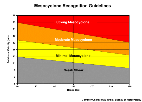
OSF 6.5 km mesocyclone nomogram classification (Andra, 1997). This crude guide is of particular value to forecasters inexperienced in the determination of mesocyclone strength and is merely a starting point.
To determine the mesocyclone strength, use Doppler radar to:
- Read off the maximum inbound and outbound velocities (e.g., inbound value of –25 ms-1 and outbound value of +15 ms-1). In the event that the velocity couplet has no sign reversal (i.e., both velocity extrema in the couplet are either inbounds or outbounds), read off both extreme values (e.g., outbounds of 35 ms-1 and 5 ms-1).
- Add the magnitudes of the two values together and divide by 2 to obtain the rotational velocity strength. The first example in above yields a rotational velocity Vr = (|–25|+15)/2 ms-1 = 20 ms-1. For the second case above,Vr = (35 + 5)/2 ms-1 = 20 ms-1.
- Determine the range of the mesocyclone centre from the radar (in km).
- Using the rotational velocity and the range from radar, read off the strength of the mesocyclone in the nomogram
One limitation to the mesocyclone nomogram is that it is specific to 6.5 km diameter. It is important to be aware of this limitation as the nomogram could grossly under- or over- estimate the intensity of the mesocyclone in those cases where the mesocyclone has a diameter significantly smaller or larger than 6.5 km.
After classifying the strength of the mesocyclone, make sure the radar–detected rotation meets the remainder of the mesocyclone criteria:
- Diameter < 10 km
- Vertical extent > 3 km
- Persistence > 10 minutes
The mesocyclone strength nomogram is a subjective classification tool for assessing the strength of the mesocyclone. A mid-level mesocyclone is one of the few signatures that effectively require you to issue a severe thunderstorm warning, based on the direct reading of the mesocyclone strength and connection to a supercell thunderstorm. In general, however, radar information should never be used in isolation and should always be considered in conjunction with the near storm environment and any reports.
Most Likely Convective Hazards
If a thunderstorm has been determined to be severe and possesses a mid-level mesocyclone, the following convective hazards should be considered to be included in the severe thunderstorm warning:
- Destructive winds – a mesocyclone is a proxy for a supercell thunderstorm with potential to produce a very strong downdraft. Destructive winds should be considered over damaging winds due to the supercellular classification, except if you can confidently diagnose an elevated supercell. Elevated supercell downdrafts are usually well–insulated from the surface by a deep layer of potentially cold air.
- Large hail – a particularly strong updraft has the potential to produce large hail, providing the updraft extends into the hail growth layer, –10° to –30°C. Some consideration to giant hail should be taken due to the supercellular classification of the thunderstorm.
- Heavy rainfall resulting in flash flooding – flash flooding is not an automatic hazard associated with supercells, particularly for smaller or faster–moving storms. Supercells tend to have a comparatively low precipitation efficiency, but also process inordinate amounts of water vapour. The result of these two opposing drivers for heavy rainfall is that flash flooding is more likely with larger and/or slower–moving supercells.
- Tornado – only about 15% of midlevel mesocyclones are associated with tornadogenesis, based on Trapp et al.(2005). The risk of a supercell tornado should, however, be considered, especially in environments with high relative humidity in the boundary layer and strong 0–1 km shear.
See Conceptual Models for more details on why particular severe weather should be included.