
Conceptual Model
A mid-level mesocyclone is usable as the defining radar signature for a supercell thunderstorm. The presence of a mid-level mesocyclone indicates small-scale rotation in the vicinity of or inside a storms updraft. This rotational flow is associated with the presence of vertical vorticity which has been created through tilting of ambient horizontal vorticity (inherent in environmental vertical shear) by a strong convective updraft and subsequently stretched due to vertically accelerating parcels in the updraft. For a more complete description of these processes, see the Supercell Conceptual Model.
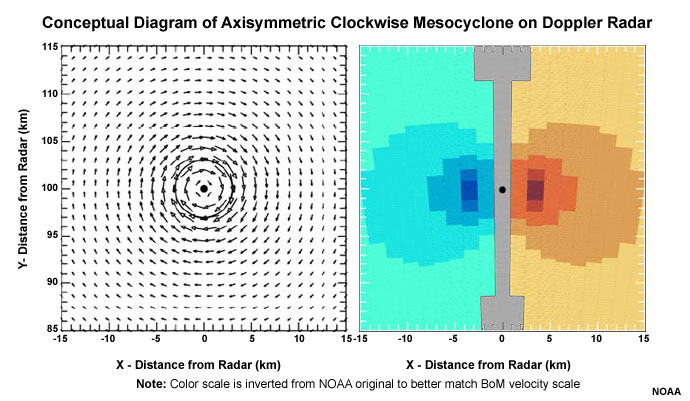
Doppler velocity pattern of a typical southern hemisphere mesocylcone (clockwise circulation) that has peak tangential velocities of 25 m/s (49 kt) at a radius of 3 km from the circulation center (black dot); radius of maximum winds is indicated by circle. Arrow length is proportional to wind speed. The image on the right shows how this circulation would appear in the base velocity of a Doppler radar.
A persistent Mid-level Mesocyclone signature indicates a strong and reasonably steady rotating updraft associated with a supercell. Generally, supercells can produce all four of the severe convective hazards used to define a severe thunderstorm in Australia, with large hail and damaging winds being the most likely to occur. Many studies since the 1970s, including a climatology of US events from 2007, conclude that supercells produce severe weather far more frequently than other morphologies, and also produce more intense severe weather (e.g., Duda & Gallus, 2010).
Although the presence of a mesocyclone is associated with a risk that the parent storm may produce a tornado, recent studies have found a relatively low correlation between midlevel mesocyclone detections and observed tornadoes. Trapp et al. (2005) found that only around 15% of midlevel mesocyclone detections were tornadic. In contrast, early research from the 1970s initially suggested that as many as 50% of radar detected mesocyclones were tornadic.
Essential in the assessment of tornado potential is a consideration of the near-storm environment, particularly the vertical wind shear and relative humidity in the 0–1 km layer (Thompson 2003; Craven and Brooks 2002). Additionally, evidence of a low–level mesocyclone is more relevant for tornado potential than consideration of midlevel mesocyclones.
Determining Thunderstorm Classification
A significant, persistent mid-level mesocyclone is, by definition, part of a supercell. Generally, to help determine or confirm the classification of the thunderstorm you are observing, use the following flow chart to help diagnose which thunderstorm conceptual model you should consider more closely.

See Supercell for more information.