
Supercell Structure on Radar
The strength, relative steadiness, longevity and association with storm-scale rotation of a supercell updraft leads to an often distinctive four-dimensional arrangement of hydrometeors and storm-scale flow pattern as seen by radar. Embedded within this arrangement are usually several, sometimes even most of the reflectivity and velocity signatures presented in this guide. For a mature, "classic" supercell these signatures usually show a characteristic spatial arrangement relative to each other. The description of this arrangement is the primary goal of this section.
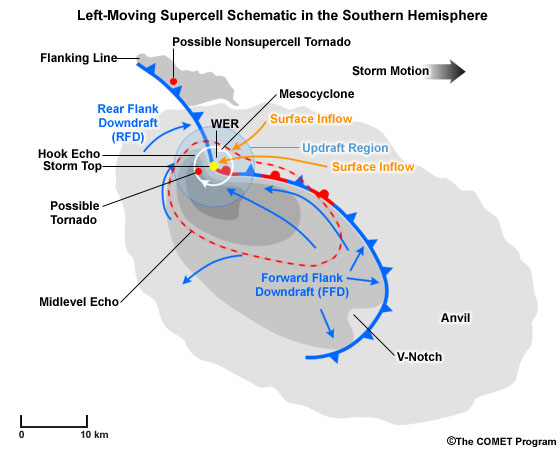
Fig. 1: Conceptual image of a left-moving supercell in the southern hemisphere combining elements observed by satellite, radar and conceptual features. The Anvil and Flanking Line are observable in the visible satellite channel. The bean-shaped grey shaded area marks the near-ground radar reflectivity echo, whereas the red outline shows the corresponding stronger (40 dBZ+) echo at the storms midlevels. Some individual radar signatures and storm structure elements are also shown.
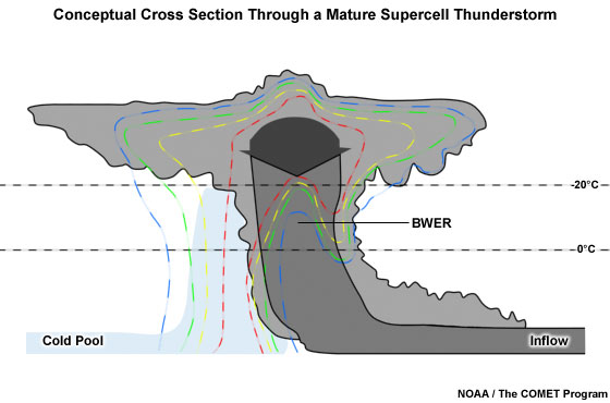
Fig. 2: Cross section through a mature supercell thunderstorm showing a conceptual cloud outline and characteristic reflectivity distribution. The blue shading represents the storm's cold pool.
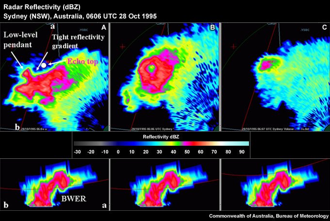
Fig. 3: Three quasi-horizontal slices through the reflective structure of a left-moving supercell. Panel A shows a low-level slice with a pronounced tight low-level reflectivity gradient on the northern flank and a hook echo. Panel B shows a very distinct Bounded Weak Echo Region (BWER) roughly located above the low-level reflectivity gradient and below the storm top shown in panel C. The lower panels shows a vertical cross section through the storm along line ab.
At low levels supercells are often characterised by a sharp, low-level reflectivity gradient on the inflow side of the storm (Figs 1, 2, 3A). This enhanced gradient often extends away from a low-level inflow notch to its west and marks the interface between the low-level inflow and the storms cold pool (Fig. 2) and could exhibit an enhanced low-level convergence signature. If the storm possesses low-level rotation, the circulation would most likely set up near the interface of the low-level updraft and the Rear Flank Downdraft (RFD) in the vicinity of the hook echo (Fig. 1 and Fig. 3). Damaging low-level winds are very likely near the low-level mesocyclone and the adjacent regions of the RFD.
A Weak Echo Region (WER) often extends upward from the low-level tight reflectivity gradient. A WER is a very common feature of any severe storm in a vertically sheared environment. Supercells often contain very intense updrafts that prevent any large hydrometeors from forming until the updraft air has reached anvil level, thus creating a Bounded Weak Echo Region (BWER). A BWER is connected to precipitation descending around the updraft on all sides, including the upshear side (Fig. 2, Fig. 3B). A BWER is best seen as a "doughnut hole" of weaker reflectivity surrounded by much stronger reflectivity at midlevels (Fig. 3B). A mid-level mesocyclone is usually found fairly close to the BWER centre, but a BWER should not be regarded as a vortex centrifuging hydrometeors to larger radii. Intense reflectivity maxima are likely close to the WER or BWER, extending down to near the low-level reflectivity gradient. These gradients mark falling, large hail which is partially melting on the way to the ground. The level around the melting layer for large hail is also a preferred region in which to observe the S-band Three-Body Scatter Spike (TBSS). At this level, and below this level, a V-notch or forward flank notch might be observable in the radar reflectivity (Fig. 1).
At anvil level, near the top of the storm, the high-level 50 dBZ storm top signature is usually found above the BWER at midlevels or the tight gradient at low levels. The storm top often appears as a single isolated echo top; the storm top is "displaced" from the location of the low-level echo core (Figs. 1, 2, 3). At this level a pronounced storm top divergence signature marks the evacuation of air from the updraft interacting with its equilibrium level (usually the tropopause). This outflowing air in itself moves out radially from the updraft as a point source, but strong anvil-level storm-relative winds distort the radial flow field considerably.
Of note is the mesocyclone evolution. Initially, a midlevel mesocyclone forms at the level of maximum vortex tilting. The mesocyclone then grows up and down from midlevels and the RFD forms. Mature mesocyclones show convergent rotation at low levels, pure rotation in the midlevels, and divergent rotation aloft. At low levels, the mesocyclone is part updraft, part RFD with lifting and horizontal vortex line tilting accomplished by the RFD gust front. Higher up, at midlevels, the mesocyclone consist mainly of updraft. At low levels, the thermodynamic stability of the RFD (as it wraps into the mesocyclone circulation) drives whether the low-level mesocyclone occludes and dies or if tornadogenesis occurs.
All of the signatures described in this guide except the "Bow Echo and Strong Rear Inflow Jet" can be found in a mature supercell:
Low-level Signatures
- Damaging Near-Surface Winds
- Hook Echo
- Low-level Convergence
- Low-level Mesocyclone
- Tight Low-level Reflectivity Gradient
Mid-level Signatures
- Forward Flank Notch
- Midlevel Mesocyclone
- Three-body Scatter Spike
Upper-level Signatures
- 50 dBZ Echo Top Height
- Single Cell
- Anomalous Storm Propagation
- Storm Top Divergence
Multi-level Signatures
- Bounded Weak Echo Region
- Very High Reflectivity
- Weak Echo Region