
Supercell Environments
The most discriminating environmental parameter usable for forecasting supercell potential is the strength of the deep layer shear. "Deep layer" refers to a height that should at least extend through half the storm depth. For warm season storms, deep-layer shear is typically measured in the 0-6 km layer above ground level. Cloud model simulations by Weisman and Klemp (1982), along with observational studies by Markowski et al. (1998), Rasmussen and Blanchard (1998), and Bunkers (2002), indicate that a vector shear magnitude of roughly 15-20 m/s (30-40 knots) over the lowest 6 km is necessary to support supercells. A large climatology by Thompson et al. (2003) shows that the 0-6 km bulk shear vector magnitude is an excellent discriminator between "ordinary cells", marginal supercells and supercells (Fig. 1).
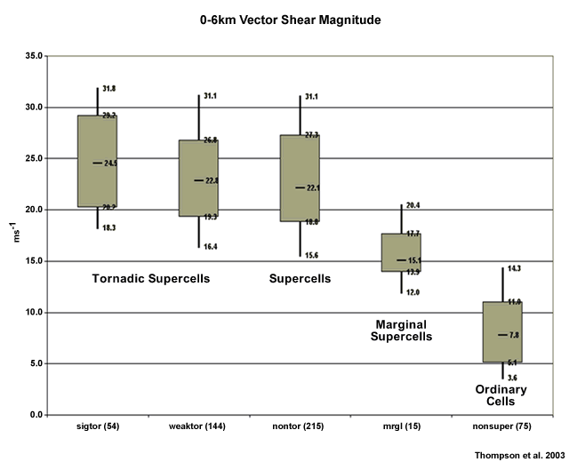
Fig. 1: Discrimination between various storm types using the 0-6 km shear magnitude as the discriminator.
Deep-layer shear, however, is not overly useful in discriminating between tornadic and non-tornadic supercells. Low-level parameters such as the height of the lifted condensation level (LCL) and the 0-1 km shear vector magnitude are far better predictors for this type of discrimination (Fig. 2).
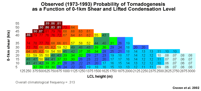
Fig. 2: Probability of tornadogenesis as a function of two storm-environmental parameters: the 0-1 km shear and the height of the Lifted Condensation Level (LCL). Only 1800 LST soundings were used in the underlying climatology of Craven et al. (2002).
Overall, it is now tempting to list a set of environmental ingredients that are required for the probable occurrence of supercells. Such ingredients would be the combination of generic ingredients for (generally) surface-based storms, such as buoyancy and lift, in addition to some type of deep-layer shear criterion to organise the storm.
One such attempt is the supercell composite parameter (Thompson et al., see http://w1.spc.woc.noaa.gov/publications/thompson/stp_scp.pdf) which combines two diagnostics, one for buoyancy and another for storm-scale rotation, with the 0-6 km shear magnitude.
A second, more detailed approach, is the National Thunderstorm Forecast Guidance System (NTFGS) in Australia. Based on mesoscale numerical model input, a range of parameters need to exceed climatologically based (and model-tuned) thresholds for a simple on/off supercell decision (Table 1).
| Surface Lifting | |
|---|---|
| LI (500) OR LI (700) for cool-season TS | ≤ -1 C |
| EL | ≤ -20 C |
| Max Upmotion sigma 0.9988-0.8500 | ≥ 10 hPa/hr |
| | CIN | | ≤ 25 J/kg |
| Cold cloud depth | ≥ 3 km |
| Cool-Season (850hPa Temp <12) | ||
|---|---|---|
| Favourable | Very Favourable | |
| LI (700) | ≤ -2 | ≤ -4 |
| Max shear sigma 0.9875-1.5 -3 km | ≥ 30 | ≥ 35 |
| Warm-Season (850hPa Temp ≥12) | ||
|---|---|---|
| Favourable | Very Favourable | |
| LI (500) | ≤ -4 | ≤ -5 |
| Max shear sigma 0.9875-2.5 - 4 km | ≥ 30 | ≥ 35 |
Table 1: Thresholds for surface-based thunderstorm and supercell on/off decisions within the National Severe Thunderstorm Forecast Guidance System (NTFGS) in Australia.
The above thresholds attempt to quantify "sufficient" buoyancy (LI), chance of initiation (sigma; CIN) and shear for the possible development of supercells. The NTFGS accuracy is limited but the system embodies the useful concept of what type of ingredients of what approximate magnitudes need to overlap to support supercell development.
Demise of a Supercell
There are several ways to see the demise of a supercell, including:
- Its own cold pool eventually cuts off the supply of potentially unstable air ("outflow dominance").
- The storm moves into a thermodynamically or dynamically unfavourable environment.
- An intensifying cold pool induces the storm to transition into a high-precipitation supercell or to grow upscale into a squall line or bow echo.
- The storm interacts with other storms and suffers from seeding, neighbouring outflows being undercut by outflows from neighbouring storms.